P.Z. 12-2015 Warwick on White Road (1050 and 1060 White Rd.)
NOTICE OF PUBLIC HEARING
CITY OF CHESTERFIELD
PLANNING COMMISSION
NOTICE IS HEREBY GIVEN that the Planning Commission of the City of Chesterfield will hold a Public Hearing on Monday, January 11, 2016 at 7:00 p.m. in the City Council Chambers at Chesterfield City Hall, 690 Chesterfield Parkway West, Chesterfield, Missouri 63017.
Said Hearing will be as follows:
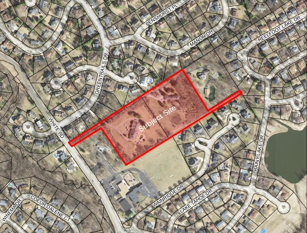
P.Z. 12-2015 Warwick on White Road (1050 and 1060 White Rd.): A request for a zoning map amendment from a “NU” Non-Urban District to a “R-2” Residence District for a 8.31 acre tract of land located southeast of the intersection of White Road and Greentrails Drive (18R620266 and 18R340902).
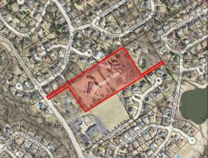
For a larger image of the site, please click HERE.
PERMITTED USES:
For a list of the Permitted Uses, please click HERE.
Anyone interested in the proceedings will be given an opportunity to be heard. Copies of the request are available for review in the Department of Public Services at Chesterfield City Hall, 690 Chesterfield Parkway West during weekdays between the hours of 8:30 a.m. and 4:30 p.m. If you should need additional information about this project, please contact Ms. Jessica Henry, Project Planner, by telephone at 636-537-4741 or by email at jhenry@chesterfield.mo.us
CITY OF CHESTERFIELD
Stanley Proctor, Chair
Chesterfield Planning Commission
PROPERTY DESCRIPTION
A tract of land being part of U.S. Surveys 109 and 366 in Township 45 North, Range 4 East of the Fifth Principal Meridian, City of Chesterfield, St. Louis County, Missouri and being more particularly described as follows:
BEGINNING at the Point of intersection of the Eastern line of White Road, 40 feet wide with the Northwestern line of U.S. Survey 366; thence along the Northwestern line of said U.S. Survey 366 and the Northwestern line of U.S. Survey 109 North 58 degrees 00 minutes 00 seconds East, 1119.61 feet to the Northernmost corner of a tract of land described in a deed to Raymond and Rosemarie Dunn as recorded in Deed Book 6863, Page 2388 of the St. Louis County Records; thence along the Northwestern line of said tract South 31 degrees 44 minutes 26 seconds East, 407.80 feet to the Southernmost corner thereof; thence along the Southeastern line of said Dunn tract North 58 degrees 00 minutes 00 seconds East, 320.45 feet to the Easternmost corner thereof, said point being on the Northeastern line of a tract of land described in a deed to YMA Group as recorded in Deed Book 12519, Page 2034 of the St. Louis County Records; thence along said Northeastern line South 31 degrees 44 minutes 26 seconds East, 9.52 feet to the Easternmost corner of said YMA Group tract; thence along the Southeastern line of said YMA Group and the Southeastern line of a tract of land described in a deed to T&C Properties, LLC as recorded in Deed Book 20760, Page 1145 of the St. Louis County Records South 58 degrees 00 minutes 00 seconds West, 1135.91 feet to the Southernmost corner of the T&C Properties, LLC tract; thence along the Southwestern line of said tract North 34 degrees 43 minutes 11 seconds West, 367.73 feet to a point on the Southeastern line of a 50-foot wide strip described in the aforesaid Deed Book 20760, Page 1145; thence along the Southeastern line of said tract South 58 degrees 00 minutes 00 seconds West, 282.92 feet to a point on the aforesaid Northeastern line of White Road; thence along said Northeastern line North 34 degrees 10 minutes 12 seconds West, 50.04 feet to the Point of Beginning according to a survey by Stock & Associates Consulting Engineers, Inc. during October, 2015 and containing 362,016 square feet or 8.310 acres more or less.