P.Z. 16-2019 1420 Schoettler Road and 15000 South Outer Forty Road
NOTICE IS HEREBY GIVEN that the Planning Commission of the City of Chesterfield will hold a Public Hearing on Monday, January 13, 2020 at 7:00 p.m. in the Council Chambers at Chesterfield City Hall, 690 Chesterfield Parkway West, Chesterfield Missouri 63017.
Said Hearing will be as follows:
P.Z. 16-2019 1420 Schoettler Road and 15000 South Outer Forty Road: A request for a zoning map amendment from the “NU” Non-Urban District to the “E-1/2AC” Estate Half Acre District for two tracts of land totaling 6.00 acres located on the east side of Schoettler Road, north of its intersection with Grantley Drive (19S640262), (19R430165).
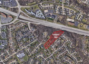
For a larger image of the site, please click HERE.
Anyone interested in the proceedings will be given an opportunity to be heard. Copies of the request are available for review in the Department of Planning & Development Services at Chesterfield City Hall, 690 Chesterfield Parkway West during weekdays between the hours of 8:30 a.m. and 4:30 p.m. If you should need additional information about this project, or for a list of requested uses, please contact Mr. Chris Dietz, Planner, by telephone at 636-537-4745 or by email at cdietz@chesterfield.mo.us.
CITY OF CHESTERFIELD
Merrell Hansen, Chair
Chesterfield Planning Commission
PROPERTY DESCRIPTION
A tract of land being Lots 2 and 3 of SJM Estates, a subdivision filed for record in Plat Book 200, page 47, of the St. Louis County, Missouri records all being in Township 45 North, Range 4 East of the Fifth Principal Meridian, City of Chesterfield, St. Louis County, Missouri and being more particularly described as follows:
BEGINNING at a point on the Northeastern line of Schoettler Road being the Southwest corner of Lot 3 of SJM Estates, a subdivision filed for record in Plat Book 200, Page 47 of the St. Louis County records; thence along the Northwestern line of said Lot 2 North 42 degrees 55 minutes 13 seconds East, 540.00 feet to the Northeast corner thereof, being the Southwest corner of Lot 3; thence along the Western line of Lot 3 thence North 47 degrees 04 minutes 47 seconds West, 58.28 feet to a point; thence North 42 degrees 55 minutes 13 seconds East, 328.11 feet to a point; thence North 84 degrees 16 minutes 13 seconds East, 117.80 feet to a point; thence North 71 degrees 28 minutes 13 seconds East, 170.00 feet to a point on the southern line of Missouri State Highway I-64; thence along said right of way line North 44 degrees 41 minutes 13 seconds East 16.85 feet to a point; thence South 13 degrees 43 minutes 13 seconds West, 20.23 feet to a point; thence South 75 degrees 45 minutes 32 seconds East, 151.68 feet to the Northeast corner of Lot 3; thence along the Southeast line of Lots 3 and 2 South 45 degrees 15 minutes 13 seconds West, 1,216.83 feet to the aforesaid Northeastern line of Schoettler Road; thence along said line North 33 degrees 33 minutes 47 seconds West, 177.15 feet to a point; thence North 55 degrees 44 minutes 47 seconds West, 22.73 feet to the Point of Beginning and containing 6.00 acres more or less as per calculations by Stock & Associates Consulting Engineers, Inc. during July, 2016.