P.Z. 14-2015 Friendship Village of West County (15201, 15239, 15249, 15255 Olive Blvd)
NOTICE OF PUBLIC HEARING
CITY OF CHESTERFIELD
PLANNING COMMISSION
NOTICE IS HEREBY GIVEN that the Planning Commission of the City of Chesterfield will hold a Public Hearing on Monday, January 25, 2016 at 7:00 p.m. in the City Council Chambers at Chesterfield City Hall, 690 Chesterfield Parkway West, Chesterfield, Missouri 63017.
Said Hearing will be as follows:
P.Z. 14-2015 Friendship Village of West County (15201, 15239, 15249, 15255 Olive Blvd): A request to amend Conditional Use Permit (CUP) #36 to include additional area and to amend the use restrictions and other development conditions in a “R4” Residential District for a 36.7 acre tract of land at the northwest corner of Olive Boulevard and Arrowhead Estates Lane (17S320445, 18S640272, 18S640326, 18S640162).
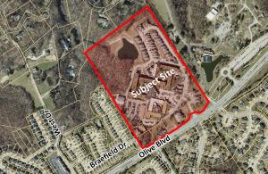
For a larger image of the site, please click HERE.
The requested Conditional Use is as follows:
- Nursing Homes
Anyone interested in the proceedings will be given an opportunity to be heard. Copies of the request are available for review in the Department of Public Services at Chesterfield City Hall, 690 Chesterfield Parkway West during weekdays between the hours of 8:30 a.m. and 4:30 p.m. If you should need additional information about this project, please contact Mr. Jonathan Raiche, Senior Planner, by telephone at 636-537-4736 or by email at jraiche@chesterfield.mo.us
CITY OF CHESTERFIELD
Stanley Proctor, Chair
Chesterfield Planning Commission
PROPERTY DESCRIPTION
A tract of land being all of Lot A of the Friendship Village of West County, a subdivision recorded in Plat Book 356 Page 143, and three tracts of land being part of Lot 2 of the Hugo Essen Farm in U.S. Survey 154 and 157, Township 45 North, Range 4 East as recorded in Deed Book 21170 Page 286, Deed Book 21170 Page 391 and Deed Book 21170 Page 315 of the St. Louis County Land Records office in St. Louis County, Missouri, being more particularly described as follows:
Beginning at found 1/2" rebar with cap stamped "Marler 347-D" being the Southeastern corner of Lot A of the Friendship Village of West County Boundary Adjustment Plat as aforementioned, being on the Northern right of way line of Olive Boulevard (Variable Width) and on the Southwestern Line of Faust Park as conveyed to St. Louis County by Deed Book 6320 Page 1227; thence Southwesterly along the Northern line of said Olive Boulevard the following courses and distances, South 32 Degrees 30 Minutes 32 Seconds West a distance of 132.25 feet to a point from which a found rebar with cap "L.S. 134-D bears North 21 degrees 49 minutes West 0.12 feet; thence South 58 Degrees 18 Minutes 50 Seconds West a distance of 66.98 feet to a point from which a found 5/8" rebar bears North 24 degrees 05 minutes East 0.1 feet; thence North 72 Degrees 06 Minutes 11 Seconds West a distance of 53.16 feet to a found 1/2" rebar with cap stamped "Marler 347-D"; thence South 61 Degrees 49 Minutes 45 Seconds West a distance of 75.01 feet to a found 1/2" rebar with cap stamped "Marler 347-D"; thence South 16 Degrees 21 Minutes 14 Seconds West a distance of 68.59 feet to a found 1/2" rebar with cap stamped "Marler 347-D"; thence South 53 Degrees 21 Minutes 49 Seconds West a distance of 172.33 feet to a point from which a found bent R/W marker bears South 26 degrees 48 minutes 0.45 feet; thence South 58 Degrees 21 Minutes 41 Seconds West a distance of 494.44 feet to a found 5/8" rebar with aluminum cap; thence South 63 Degrees 56 Minutes 01 Seconds West a distance of 41.19 feet to a point from which a found 5/8" rebar with aluminum cap bears South 0.1 feet; thence South 66 Degrees 53 Minutes 32 Seconds West a distance of 17.48 feet to a point on the Eastern line of Braefield, a subdivision recorded in Plat Book 331 Page 80-81 from which a found 1/2" iron pipe with Cap "L.S. 78-D" bears South 30 degrees 34 minutes East 0.25 feet; thence leaving the Northern line of Olive Boulevard along the Eastern line of aforesaid Braefield and the extension thereof, North 30 Degrees 33 Minutes 39 Seconds West a distance of 1489.19 feet to a found concrete monument being the Northwestern corner of aforementioned Lot A; thence along the Northern line of said Lot A, North 53 Degrees 49 Minutes 20 Seconds East a distance of 1033.70 feet to a found 1/2" rebar with cap "Marler 347-D" being the Northeast corner of aforesaid Lot A and being on the Southwestern line of aforesaid Faust Park; thence along the Southwestern line of Faust Park, South 32 Degrees 06 Minutes 20 Seconds East a distance of 1503.73 feet to the point of beginning containing 1,598,939 square feet of 36.70± acres more or less as surveyed by Marler Surveying Company, Inc.