P.Z. 20-2019 Briarcliffe Villas (14001 Olive Blvd)
NOTICE IS HEREBY GIVEN that the Planning Commission of the City of Chesterfield will hold a Public Hearing on Monday, February 10, 2020 at 7:00 p.m. in the Council Chambers at Chesterfield City Hall, 690 Chesterfield Parkway West, Chesterfield Missouri 63017.
Said Hearing will be as follows:
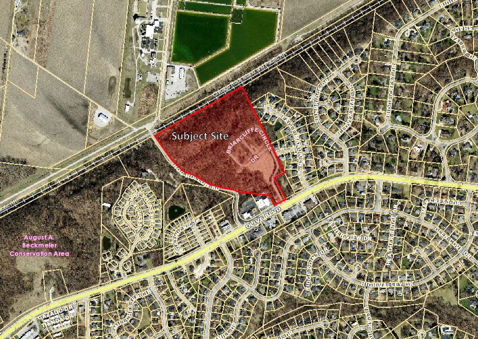
P.Z. 20-2019 Briarcliffe Villas (14001 Olive Blvd): A request for a change in zoning from R-3 Residence District to PUD Planned Unit Development for a maximum of 117 residential units (16R340151).
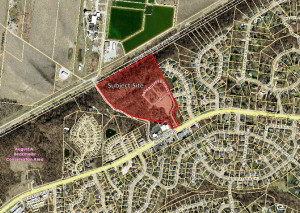
For a larger image of the site, please click HERE.
Anyone interested in the proceedings will be given an opportunity to be heard. Copies of the request are available for review in the Department of Planning at Chesterfield City Hall, 690 Chesterfield Parkway West during weekdays between the hours of 8:30 a.m. and 4:30 p.m. If you should need additional information about this project, or for a list of requested uses, please contact Ms. Annisa Kumerow, Planner, by telephone at 636-537-4743 or by email at akumerow@chesterfield.mo.us.
CITY OF CHESTERFIELD
Merrell Hansen, Chair
Chesterfield Planning Commission
PROPERTY DESCRIPTION
A tract of land in Lot 11 of D.J. Talbot Subdivision in U.S. Survey 2030, according to the plat thereof recorded in Plat Book 7 Page 43 of the St. Louis City (former County) Records and partly in U.S. Survey 206 Township 46 North Range 4 East in St. Louis County, Missouri more particularly described as:
Beginning at a point in the center line of Hog Hollow Road, 40 feet wide, at its intersection with the South line of U.S. Survey 2030; thence along the center line of said road, North 45 degrees 03 minutes 31 seconds West, 86.69 feet; North 74 degrees 44 minutes 26 seconds West, 142.55 feet; North 47 degrees 14 minutes 26 seconds West, 211.20 feet and North 28 degrees 14 minutes 26 seconds West, 356.40 feet and North 07 degrees 12 minutes 34 seconds East, 85.40 feet to the south right-of-way line of the Missouri Central Rail Road Company, 100 feet wide; thence along said right-of-way line the following courses and distances: North 63 degrees 04 minutes 34 seconds East, 699.83 feet to a point of curvature to the left having a radius of 5,787.48 feet, an arc length of 242.07 feet and a chord which bears North 61 degrees 52 minutes 40 seconds East, 242.06 feet and North 60 degrees 40 minutes 46 seconds East, 257.43 feet to its intersection with the northwesterly prolongation of the western line of Eagle Ridge, a subdivision according to the plat thereof as recorded in Plat Book 344, Page 175 of the St. Louis County Records; thence departing said right-of-way line along said prolongation line and the western line of Eagle Ridge, South 25 degrees 49 minutes 00 seconds East, 1,176.10 feet to the northern corner of a tract of land as conveyed to WLF Investments LLC by instrument recorded in Book 21584, Page 1944 of above said records; thence along the northwest line of said WLF Investments LLC tract, South 64 degrees 11 minutes 00 seconds West, 145.90 feet to the western corner thereof; thence South 25 degrees 49 minutes 00 seconds East, 301.42 feet to the northwestern right-of-way line of Olive Boulevard, thence along said right-of-way line, South 61 degrees 59 minutes 00 seconds West, 148.50 feet to the southeastern corner of a tract of land as conveyed to Keymer Realty and Investments, LLC by instrument recorded in Book 21422, page 725 of above said records; thence along the eastern line of said Keymer tract, North 28 degrees 33 minutes 00 seconds West, 173.94 feet to the southeastern tract of land as awarded to Harvey A. and Sandra S. Keymer under Cause No. 09SL-CC023205 filed in the Circuit Court of St. Louis County; thence along the eastern and northern lines of said cause the following courses and distances: North 75 degrees 52 minutes 59 seconds East, 3.20 feet; North 14 degrees 07 minutes 01 seconds West, 10.86 feet; North 30 degrees 56 minutes 43 seconds West, 17.06 feet to the beginning of a non-tangent curve to the left having a radius of 46.59 feet; along said curve with an arc length of 57.24 feet and a chord which bears North 83 degrees 38 minutes 06 seconds West, 53.71 feet and South 61 degrees 11 minutes 37 seconds West, 37.17 feet to the south line of above said U.S. Survey 2030; thence along said south line, North 82 degrees 32 minutes 26 seconds West, 760.09 feet to the Point of Beginning and Containing 1,281.082 square feet or 29.410 acres more or less according to calculations performed by Stock and Associates Consulting Engineers, Inc. on June 12, 2019.