P.Z. 22-2017 Clarkson Center (2264 Clarkson Road)
NOTICE OF PUBLIC HEARING
CITY OF CHESTERFIELD
PLANNING COMMISSION
NOTICE IS HEREBY GIVEN that the Planning Commission of the City of Chesterfield will hold a Public Hearing on Monday, February 12, 2018 at 7:00 pm, in the Council Chambers at City Hall, 690 Chesterfield Parkway West, Chesterfield, Missouri 63017.
Said Hearing will be as follows:
P.Z. 22-2017 Clarkson Center (2264 Clarkson Road): A request for a zoning map amendment from an “R2” Residence District (15,000 square foot minimum) to a “PC” Planned Commercial District for 0.9 acres located on the southern corner of the intersection of Clarkson Road and Clarkson Woods Drive. (20T610716).
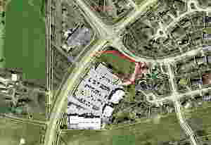
For a larger image of the site, please click HERE.
Anyone interested in the proceedings will be given an opportunity to be heard. Copies of the request are available for review in the Department of Planning and Development Services at Chesterfield City Hall, 690 Chesterfield Parkway West during weekdays between the hours of 8:30 a.m. and 4:30 p.m. If you should need additional information about this project, or for a list of permitted uses, please contact Ms. Cassie Harashe, Project Planner, by telephone at 636-537-4745 or by email at charashe@chesterfield.mo.us
CITY OF CHESTERFIELD
Merrell Hansen, Chair
Chesterfield Planning Commission
PROPERTY DESCRIPTION
A tract of land in north ½ of Section 21, Township 45 North, Range 4 East, St. Louis County, Missouri, being more particularly described as follows:
Beginning at a point in the east and west centerline of said Section 21, Township 45 North, Range 4 East; said point being distant eastwardly along said east and west centerline North 89 degrees 48 minutes 58 seconds East 420.82 feet from the intersection of said east and west centerline with the east line of Clarkson Road, 60 feet wide; thence North 27 degrees 44 minutes 50 seconds East 434.89 feet to a point; thence North 17 degrees 01 minutes 17 seconds East 150 feet to a point; thence along a curve to the right, whose radius point bears South 72 degrees 58 minutes 43 seconds East 20 feet from the last mentioned point, a distance 29.60 feet to a point; thence along a curve to the right, whose radius point bears North 11 degrees 48 minutes 19 seconds East 475 feet from the last mentioned point, a distance of 151.74 feet to a point; thence North 59 degrees 53 minutes 27 seconds West 137 feet to a point; thence along a curve to the left, whose radius point bears South 30 degrees 06 minutes 33 seconds West 40 feet from the last mentioned point, a distance of 51.81 feet to a point in the southeast line of Clarkson Road, 60 feet wide; thence Southwestwardly along said southeast line of Clarkson Road along a curve to the left, whose radius point bears South 44 degrees 06 minutes 11 seconds East 1402.69 feet from the last mentioned point, a distance of 773.00 feet to the east and west centerline of said Section 21, Township 45 North, Range 4 East, thence along said east and west centerline North 89 degrees 48 minutes 58 seconds East 420.82 feet to the point of beginning.
Excepting there from that part which has been subdivided and is now known as Lot 1 of Clarkson Centre Subdivision according to the Plat Book 267 Page 70 of the St. Louis County Recorder’s Office.