P.Z. 01-2018 Clarkson Square (1709 Clarkson Rd) Ordinance Amendment
NOTICE OF PUBLIC HEARING
CITY OF CHESTERFIELD
PLANNING COMMISSION
NOTICE IS HEREBY GIVEN that the Planning Commission of the City of Chesterfield will hold a Public Hearing on Monday, March 12, 2018 at 7:00 p.m. in the Council Chambers at Chesterfield City Hall, 690 Chesterfield Parkway West, Chesterfield, Missouri 63017.
Said Hearing will be as follows:
P.Z. 01-2018 Clarkson Square (1709 Clarkson Rd) Ordinance Amendment: A request to amend Ordinance 2169 to amend the development conditions to remove the restriction on the number of restaurants in a “C-8” Planned Commercial District for a 34.8 acre tract of land located north of Baxter Road and on the west side of Clarkson Road.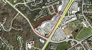 For a larger image of the site, please click HERE.
Anyone interested in the proceedings will be given an opportunity to be heard. Copies of the request are available for review in the Department of Planning & Development Services at Chesterfield City Hall, 690 Chesterfield Parkway West during weekdays between the hours of 8:30 a.m. and 4:30 p.m. If you should need additional information about this project or for a list of requested uses, please contact Ms. Cecilia Dvorak, Project Planner, by telephone at 636-537-4738 or by email at cdvorak@chesterfield.mo.us
CITY OF CHESTERFIELD
Merrell Hansen, Chair
Chesterfield Planning Commission
PROPERTY DESCRIPTION
A tract of land being Lot B of “Clarkson Square Plat Four”, a subdivision according to the plat thereof recorded as Daily No. 428 on April 30, 1985 in the St. Louis County Records, Lot 1 of “Boundary Adjustment Plat of Lots 1 and 2 of Clarkson Square Plat One” recorded as Daily No. 1 on April 2, 1984 in the St. Louis County Records, and "Adjusted Lot 2 of Clarkson Square Plat One” recorded as Daily No. 565 on June 12, 1984 in the St. Louis County Records, all in U.S. Survey 2002, Township 45 North Range 4 East, St. Louis County, Missouri and being more particularly described as:
Beginning at the intersection of the Northeast line of Baxter Road, 80 feet wide, with the Southeast line of property conveyed to Elizabeth Jones Sands, et al by deed recorded in Book 4127, Page 326 of the St. Louis County Records; said point being also the most western corner of said Adjusted Lot 2; thence in a general Northeastwardly direction along the Southeast line of said Sands property, the Southeast line of property conveyed to Benjamin Houlihan, Jr. and wife by deed recorded in Book 7341, Page 1167 of the St. Louis County Records and the Southeast line of property conveyed to Richard P. Rounce and wife bid* recorded in Book 4798, Page 9 of the St. Louis County Records, the following courses and distances: North 62 degrees 06 minutes 57 seconds East 176.55 feet, North 25 degrees 25 minutes 15 seconds East 134.81 feet, North 49 degrees 20 minutes 55 seconds East 248.74 feet, North 63 degrees 21 minutes 24 seconds East 170.86 feet, North 87 degrees 29 minutes 23 seconds East 204.03 feet, and North 53 degrees 26 minutes 32 seconds East 408.04 feet to a point in the South line of property conveyed to County Home Improvement Center, Inc. by deed recorded in Book 7501, Page 1857 of the St. Louis County Records; thence Eastwardly along said South line, South 63 degrees 40 minutes 18 seconds East 148.21 feet to a point in the West line of property dedicated to the Missouri Highway and Transportation Commission by the record plat of "Clarkson Square Plat One", a subdivision according to the plat thereof recorded in Plat Book 218, Pages 42 and 43 of the St. Louis County Records; thence Southwardly along said West line, South 26 degrees 19 minutes 42 seconds West 36.00 feet to a point in the North line of Lot A of aforesaid "Clarkson Square Plat Four"; thence along the North, West, and South lines of said Lot A of "Clarkson Square Plat Four" the following courses and distances: North 59 degrees 08 minutes 38 seconds West 50.17 feet, along a curve to the left whose radius point bears South 30 degrees 51 minutes 22 seconds West 52.00 feet from the last mentioned point, a distance of 85.90 feet, South 26 degrees 12 minutes 47 seconds West 125.67 feet, and South 55 degrees 15 minutes 00 seconds East 174.32 feet to a point in the aforesaid West line of property dedicated to the Missouri Highway and Transportation Commission; thence along said West line South 28 degrees 55 minutes 44 seconds West 357.67 feet to a point in Northeast line of Lot 4 of aforesaid "Clarkson Square Plat One"; thence along the Northeast, Northwest and Southwest line of said Lot 4 the following courses and distances: North 55 degrees 15 minutes 00 seconds West 122.64 feet, South 34 degrees 53 seconds East 142.15 feet to a point in the aforesaid West line of property dedicated to the Missouri Highway and Transportation Commission; thence along said West line South 30 degrees 56 minutes 00 seconds West 185.53 feet to the Northeast corner of Adjusted Lot 3 as shown on the "Boundary Adjustment Plat of Lots 1 and 3 of Clarkson Square Plat One” recorded as Daily No. 350 on October 26, 1963 in the St. Louis County Records; thence along the boundary lines of said Adjusted Lot 3 the following courses and distances: North 59 degrees 54 minutes 20 seconds West 161.11 feet, South 34 degrees 45 minutes 00 seconds West 10.16 feet, North 55 degrees 15 minutes 00 seconds West 116.09 feet, South 34 degrees 45 minutes 00 seconds West 104.08 feet, North 55 degrees 15 minutes 00 seconds West 85.90 feet, and South 34 degrees 45 minutes 00 seconds West 190.28 feet to a point in the aforesaid Northeast line of Baxter Road, 80 feet wide; thence along said Northeast line of Baxter Road, 80 feet wide, the following courses and distances: along a curve to the right whose radius point bears North 25 degrees 55 minutes 58 seconds East 710.00 feet from the last mentioned point, a distance of 183.31 feet, along a curve to the right whose radius point bears North 37 degrees 44 minutes 59 seconds East 627.66 feet from the last mentioned point a distance of 266.92 feet, and North 27 degrees 53 minutes 03 seconds West 11.84 feet to the point of beginning and containing 12.780 acres according to a survey by Volz Engineering & Surveying, Inc. dated June, 1989.