P.Z. 02-2016 Highway 40 Park (Lot C):
NOTICE IS HEREBY GIVEN that the Planning Commission of the City of Chesterfield will hold a Public Hearing on Monday, April 11, 2016 at 7:00 p.m. in the City Council Chambers at Chesterfield City Hall, 690 Chesterfield Parkway West, Chesterfield, Missouri 63017.
Said Hearing will be as follows:
P.Z. 02-2016 Highway 40 Park (Lot C): A request for rezoning from “PC” Planned Commercial District to “PI” Planned Industrial District for a 6.8 acre tract of land at the northeast corner of Chesterfield Airport Road and Long Road (17U420147).
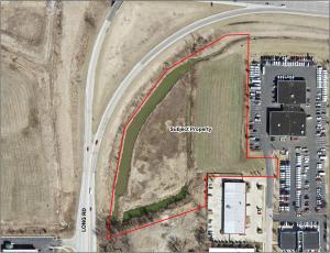
For a larger image of the site, please click HERE.
REQUESTED USES:
- Automotive retail supply
- Commercial service facility
- Industrial sales, service and storage
- Mail order sales warehouse
- Office - dental
- Office - general
- Office - medical
- Plumbing, electrical, air conditioning, and heating equipment sales, warehousing and repair facility
- Self-storage facility
- Trucks, trailers, construction equipment, agricultural equipment sales, rental, leasing, outdoor storage
- Warehouse - general
Anyone interested in the proceedings will be given an opportunity to be heard. Copies of the request are available for review from the Planning and Development Services Division at Chesterfield City Hall, 690 Chesterfield Parkway West, weekdays between the hours of 8:30 a.m. and 4:30 p.m. If you should need additional information about this project, please contact Justin Wyse, Senior Planner by telephone at 636-537-4734 or by email at jwyse@chesterfield.mo.us.
CITY OF CHESTERFIELD
Stanley Proctor, Chair
Chesterfield Planning Commission
PROPERTY DESCRIPTION
A tract of land situated in the County of St. Louis, and the State of Missouri, lying in part of U.S. Survey 126, Township 45 North, Range 4 East of the Fifth Principal Meridian, being Lot C of the Resubdivision Plat of Lot 1 of Highway Forty Park, according to the plat thereof recorded in Plat Book 347, pages 145 and 146 of the St. Louis County land records, and being part of a tract conveyed to the Moose's Team Limited Partnership in Deed Book 10347, page 1573 of said St. Louis County land records, and being more particularly described as follows:
Beginning at the intersection of the North line of property conveyed to Jelinek Eight Partnership by deed recorded in Book 8387, page 1562 of said St. Louis County records and the East line of Long Road Extension; thence Northerly along said East line as follows: North 07 degrees 27 minutes 52 seconds East, a distance of 197.27 feet; thence North 10 degrees 23 minutes 04 seconds East, a distance of 253.18 feet; thence North 36 degrees 23 minutes 56 seconds East, a distance of 282.59 feet to the South line of State Highway 40 (Interstate Highway 64); thence Easterly along said South line as follows: North 59 degrees 51 minutes 28 seconds East, a distance of 272.03 feet; thence North 87 degrees 35 minutes 17 seconds East, a distance of 89.55 feet to the Northwest corner of property conveyed as Parcel 1 to Louis J. Fusz trust by deed recorded in Book 8826 page 370 of said St. Louis County records; thence South 00 degrees 49 minutes 59 seconds West, a distance of 489.55 feet along the West line of said Parcel 1 to the Southwest corner of said Parcel 1; thence South 89 degrees 10 minutes 01 seconds East along the South line of said Parcel 1, a distance of 122.19 feet to the Northwest corner of Parcel 3 of said Fusz Property; thence South 00 degrees 49 minutes 59 seconds West, a distance of 74.86 feet along the West line of said Parcel 3 to the Northeast corner of Lot B of the said Resubdivision Plat of Lot 1; thence North 89 degrees 10 minutes 01 seconds West, a distance of 282.10 feet along the North line of said Lot B to the Northwest corner of said Lot B; thence South 01 degrees 20 minutes 13 seconds West, a distance of 119.11 feet; to the Northeast corner of property conveyed to Wilma Schneidewind by deed recorded in Book 11470 page 2326 of said St. Louis County records; thence South 71 degrees 30 minutes 37 seconds West, a distance of 414.16 feet along the North line of said Schneidewind Property and the said North line of Jelinek Property to the point of beginning. Containing 6.80 acres. Derived from record information, being said Resubdivision Plat of Lot 1.