P.Z. 07-2017 Chesterfield Valley Motor Sports (17501 N Outer 40 Rd)
NOTICE OF PUBLIC HEARING
CITY OF CHESTERFIELD
PLANNING COMMISSION
CITY OF CHESTERFIELD
PLANNING COMMISSION
NOTICE IS HEREBY GIVEN that the Planning Commission of the City of Chesterfield will hold a Public Hearing on Monday, April 24, 2017 at 7:00 p.m. in the Council Chambers at Chesterfield City Hall, 690 Chesterfield Parkway West, Chesterfield Missouri 63017.
Said Hearing will be as follows:
P.Z. 07-2017 Chesterfield Valley Motor Sports (17501 N Outer 40 Rd): A request for an amendment to an existing “C8” Planned Commercial District for a 3.0 acre tract of land located north of North Outer 40 Rd west of its Intersection with Boone’s Crossing (17U510051).
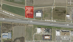
For a larger image of the site, please click HERE.
Anyone interested in the proceedings will be given an opportunity to be heard. Copies of the request are available for review in the Department of Planning and Development Services at Chesterfield City Hall, 690 Chesterfield Parkway West during weekdays between the hours of 8:30 a.m. and 4:30 p.m. If you should need additional information about this project, or for a list of requested uses, please contact Ms. Cecilia Hernandez, Project Planner, by telephone at 636-537-4738 or by email at chernandez@chesterfield.mo.us.
Anyone interested in the proceedings will be given an opportunity to be heard. Copies of the request are available for review in the Department of Planning and Development Services at Chesterfield City Hall, 690 Chesterfield Parkway West during weekdays between the hours of 8:30 a.m. and 4:30 p.m. If you should need additional information about this project, or for a list of requested uses, please contact Ms. Cecilia Hernandez, Project Planner, by telephone at 636-537-4738 or by email at chernandez@chesterfield.mo.us.
CITY OF CHESTERFIELD
Stanley Proctor, Chair
Chesterfield Planning Commission
PROPERTY DESCRIPTION
All of Lot 1 of Koester Acres located in US Surveys 125 and 126. Township 45 North. Range 4 East, in St. Louis County, Missouri as recorded in Book 207, Page 1, of the St. Louis County Land Records.
Beginning at the Southeast corner of said Lot 1, also the North right of way of Highway 40; thence North 00 degrees, 34 minutes, 00 seconds East, a distance of 441.69 feet to the Northeast corner of said Lot 1; then North 89 degrees, 26 minutes, 00 seconds West, a distance of 305.79 feet to the Northwest corner of Lot 1; thence south 00 degrees, 34 minutes, 00 seconds West, a distance of 409.50 feet to the southwest corner of Lot 1, and also being the right of way of Highway 40; thence along the right of way South 71 degrees, 07 minutes, 58 seconds East, a distance of 16.45 feet; thence South 84 degrees, 06 minutes, 40 seconds East a distance of 291.42 feet to the Point of Beginning.