P.Z. 04-2014 Chesterfield Blue Valley (Simon Woodmont Development, LLC/Chesterfield Blue Valley, LLC)
NOTICE OF PUBLIC HEARING
CITY OF CHESTERFIELD
PLANNING COMMISSION
NOTICE IS HEREBY GIVEN that the Planning Commission of the City of Chesterfield will hold a Public Hearing on Monday, April 28, 2014 at 7:00 p.m. in the City Council Chambers at Chesterfield City Hall, 690 Chesterfield Parkway West, Chesterfield, Missouri 63017.
Said Hearing will be as follows:
P.Z. 04-2014 Chesterfield Blue Valley (Simon Woodmont Development, LLC/Chesterfield Blue Valley, LLC): A request for an amendment to Ordinance 2612 to modify development criteria for 137.6 acres zoned “PC” Planned Commercial District located on the north side of Olive Street Road, west of its intersection with Chesterfield Airport Road (17W630058, 16W220010, 16W210044, 17W530190, 17W540111).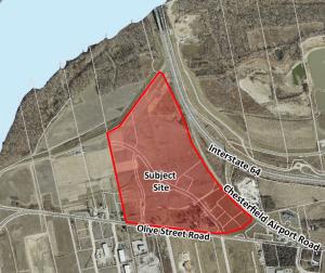
For a larger image of the site, please click HERE.
Anyone interested in the proceedings will be given an opportunity to be heard. Copies of the request are available for review in the Department of Public Services at Chesterfield City Hall, 690 Chesterfield Parkway West during weekdays between the hours of 8:30 a.m. and 4:30 p.m. If you should need additional information about this project, please contact Ms. Purvi Patel, Project Planner, by telephone at 636-537-4738 or by email at ppatel@chesterfield.mo.us
CITY OF CHESTERFIELD
Mike Watson, Chair
Chesterfield Planning Commission
Description of Property
A tract of land being Lots 2 through 5 of “Chesterfield Blue Valley Plat One”, a subdivision filed for record in Plat Book 360 Pages 256 through 259 and the “Resubdivison of Lot 1 of Chesterfield Blue Valley Plat One” a subdivision filed for record in Plat Book 362, Page 72 and 73 of the St. Louis County Missouri Records, said subdivisions being the Re-subdivision of Lot 1 of McGrath Plaza as recorded in Plat Book 325, Pages 11 and 12 and Parcel 4 of a tract of land as conveyed to William F. Brasher, Trustee by instrument recorded in Book 14298, Page 1926, both of the St. Louis County Records and part of Lots 1 through 8 of the Partition in the Estate of Conrad Kroenung as said lots were established by Report of Commissioners recorded August 13, 1879 in Book 4 Page 583 of the St. Louis County (now St. Louis City) Records, being located in U.S. Surveys 102, 368 and 371, Township 45 North, Range 3 East of the 5th Principal Meridian, City of Chesterfield, St. Louis County, Missouri and being more particularly described as follows:
Beginning at a stone marking the Southwesterly corner of above said Lot 1 of McGrath Plaza, said point being the Southeasterly corner of a tract of land as conveyed to James R. Arendt, et al by Deed Book 17113 Page 1365 of the above said Records and being on the Northern line of Olive Street Road; thence North 84 degrees 24 minutes 42 seconds West along said Northern line 1033.93 feet to the intersection of the Western line of the above said Lands of Conrad Kroenung; thence North 13 degrees 19 minutes 42 seconds West along said Western line 2019.43 feet to the center of the Chesterfield-Monarch Levee; thence departing said Western line along said center of the Chesterfield-Monarch Levee the following courses and distances: thence North 59 degrees 12 minutes 14 seconds East 310.56 feet to a point of curvature to the left, said curve having a radius of 100.00 feet; thence along last said curve with a chord which bears North 46 degrees 03 minutes 26 seconds East 45.49 feet, an arc length of 45.89 feet to a point of tangency; thence North 32 degrees 54 minutes 37 seconds East 296.44 feet; thence North 34 degrees 06 minutes 07 seconds East 586.85 feet; thence North 34 degrees 20 minutes 48 seconds East 2.86 feet; North 34 degrees 07 minutes 57 seconds East 111.64 feet; North 33 degrees 47 minutes 33 seconds East 56.93 feet; North 34 degrees 00 minutes 30 seconds East 462.42 feet; and North 35 degrees 05 minutes 58 seconds East 80.82 feet to the Westerly right-of-way line of Missouri State Highway 40 TR as established by instrument recorded in Book 6343, Page 832; thence along last said Westerly right-of-way line the following courses and distances: South 24 degrees 20 minutes 55 seconds East 10.34 feet; South 22 degrees 51 minutes 07 seconds East 602.70 feet; South 21 degrees 36 minutes 20 seconds East 757.94 feet; South 20 degrees 36 minutes 24 seconds East 457.22 feet; South 32 degrees 06 minutes 57 seconds East 717.96 feet; South 42 degrees 52 minutes 58 seconds East 102.58 feet to a point; thence along a non-tangent curve to the left, for which the radius point bears North 54 degrees 34 minutes 34 seconds East 4016.54 feet; thence along last said curve to the left an arc length of 508.24 feet to a point; thence North 47 degrees 19 minutes 34 seconds East 5.00 feet to a point; thence along a non-tangent curve to the left for which the radius point bears North 47 degrees 19 minutes 34 seconds East 4011.54 feet; thence along last said curve to the left an arc length of 304.56 feet to a point; thence North 42 degrees 58 minutes 34 seconds East 5.00 feet to a point; thence along a non- tangent curve to the left, for which the radius point bears North 42 degrees 58 minutes 34 seconds East 4006.54 feet; thence along last said curve an arc length of 604.81 feet to the Northwesterly line of Relocated Olive Street Road (38 feet wide paper street) as established by above said McGrath Plaza; thence along the last said Northwesterly line of Relocated Olive Street Road the following courses and distances: South 42 degrees 47 minutes 18 seconds West 69.46 feet to a point of curvature; thence along a curve to the right having a radius of 952.78 feet an arc length of 641.62 feet, the chord of which bears South 62 degrees 04 minutes 49 seconds West, a chord distance of 629.56 feet to the Northerly line of aforesaid Olive Street Road, thence along last said Northerly line North 84 degrees 12 minutes 42 seconds West 377.14 feet to an iron pipe at the Southeasterly corner of property conveyed to William F. Brasher, Trustee by Deed Book 14298, Page 1926 of the above said Records, thence continuing along last said north line North 84 degrees 12 minutes 42 seconds West, 628.93 feet and North 84 degrees 23 minutes 54 seconds West, a distance of 236.30 feet to the Point of Beginning, and containing 5,994,164 square feet or 137.606 acres, more or less, according to calculations by Stock and Associates Consulting Engineers on March 16, 2010.