P.Z. 06-2014 Four Seasons Plaza, Adjusted Lot 2 and Part of Adjusted Lot 1 (Caplaco Seven Inc. & Dierbergs Four Seasons Inc.)
NOTICE OF PUBLIC HEARING
CITY OF CHESTERFIELD
PLANNING COMMISSION
NOTICE IS HEREBY GIVEN that the Planning Commission of the City of Chesterfield will hold a Public Hearing on Monday, April 28, 2014 at 7:00 p.m. in the City Council Chambers at Chesterfield City Hall, 690 Chesterfield Parkway West, Chesterfield, Missouri 63017.
Said Hearing will be as follows:
P.Z. 06-2014 Four Seasons Plaza, Adjusted Lot 2 and Part of Adjusted Lot 1 (Caplaco Seven Inc. & Dierbergs Four Seasons Inc.): A request for a zoning map amendment from the “C-2” Shopping District and “PC” Planned Commercial District to create a new “PC” Planned Commercial District and to add an additional use and amend the development criteria within the existing “PC” Planned Commercial District for a 8.29 acre tract of land located on the south side of Olive Boulevard west of its intersection with Woods Mill Road (16Q220719, 16Q210763, and 16Q220690).
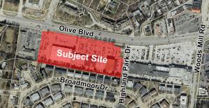
For a larger image of the site, please click HERE.
Anyone interested in the proceedings will be given an opportunity to be heard. Copies of the request are available for review in the Department of Public Services at Chesterfield City Hall, 690 Chesterfield Parkway West during weekdays between the hours of 8:30 a.m. and 4:30 p.m. If you should need additional information about this project, please contact Ms. Jessica Henry, Project Planner, by telephone at 636-537-4741 or by email at jhenry@chesterfield.mo.us
CITY OF CHESTERFIELD
Mike Watson, Chair
Chesterfield Planning Commission
Description of Property
A tract of land being Adjusted Lot 2 and part of Adjusted Lot 1 of "Boundary Adjustment of Lots 1 and 2 of Four Seasons Plat 6”, a Boundary Adjustment according to the plat thereof, recorded in Plat Book 341, Page 58 of the St. Louis County Records, situated within Lot 2 of Share 1, Lot 3 of Share 2 and Lot 5 of Share 3 of the Missouri Stevens Estate, in U.S. Survey 207, Township 46 North, Range 5 East, in the City of Chesterfield, St. Louis County, Missouri, being more particularly described as follows:
Commencing at a point on the Western right of way line of Missouri State Highway 141 (also known as Woods Mill Road, variable width) at the Southeastern corner of said Adjusted Lot 1; thence Northwesterly, along the Southern line of said Adjusted Lot 1, North 82 degrees 36 minutes 28 seconds West, 790.91 feet; thence North 78 degrees 49 minutes 30 seconds West, 15.03 feet to the Point of Beginning of the tract of land hereon described; thence Northwesterly, continuing along the Southern line of said Adjusted Lot 1 and the Southern line of Adjusted Lot 2 thereof, North 78 degrees 49 minutes 30 seconds West, 1000.85 feet to the Southeastern corner of Lot 3 of “Four Seasons Plat 6”, a Subdivision according to the plat thereof, recorded in Plat Book 171, Page 17 of the St. Louis County Records; thence Northeasterly, along the Eastern line of said Lot 3, North 11 degrees 10 minutes 30 seconds East, 366.54 feet to a point on the Southern Line of a tract of land conveyed to the State of Missouri for the widening of Missouri State Highway 340, also known as Olive Street Road, variable width,) by deed recorded in Deed Book 6919, Page 1088 of the St. Louis County Records; thence along the Southern line of said tract, South 78 degrees 49 minutes 30 seconds East, 80.00 feet to the Southeastern corner thereof; thence along the Eastern line of said tract, North 11 degrees 10 minutes 30 seconds East, 11.00 feet to a point on the Southern line of a tract of land conveyed to the State of Missouri, for the widening of said Missouri State Highway 340, by deed recorded in Deed Book 6779, Page 739 of the St. Louis County Records; thence Southeasterly, along said Southern line, South 78 degrees 49 minutes 30 seconds East, 744.54 feet to the Northwestern corner of Adjusted Lot 1, as aforementioned; thence Southwesterly, along the Western line of said Adjusted Lot 1, South 11 degrees 52 minutes 13 seconds West, 35.70 feet; thence South 71 degrees 25 minutes 29 seconds East, 68.60 feet; thence South 75 degrees 14 minutes 09 seconds East, 47.17 feet; thence South 11 degrees 45 minutes 40 seconds West 105.21 feet; thence Southeasterly, continuing along the Western line of said Adjusted Lot 1 and its Southeasterly prolongation, South 79 degrees 09 minutes 09 seconds East, 47.82 feet to a point; thence South 07 degrees 23 minutes 32 seconds West, 225.61 feet to the point of beginning, containing 8.29 acres, more or less (360,957 square feet).