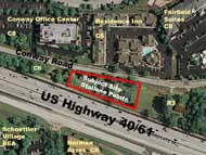
P.Z. 07-2009 Stallone Pointe (Conway Pointe LLC)
NOTICE OF PUBLIC HEARING
CITY OF CHESTERFIELD
PLANNING COMMISSION
NOTICE IS HEREBY GIVEN that the Planning Commission of the City of Chesterfield will hold a Public Hearing on Monday, June 8, 2009, in the Council Chambers at the City Hall, 690 Chesterfield Parkway West, Chesterfield, Missouri 63017.
Said hearing will be as follows:
P.Z. 07-2009 Stallone Pointe (Conway Pointe LLC): A request for a text amendment to City of Chesterfield Ordinance 2500 to revise the required improvements to Conway Road in a "PC" Planned Commercial District for a .68 acre tract of land located west of Conway Rd. and Chesterfield Parkway intersection (18S220050 and 18S310085).
       |  To view a larger image, click on the picture |  |
Anyone interested in the proceedings will be given an opportunity to be heard. Copies of the request are available for review in the Department of Planning and Public Works at the Chesterfield City Hall, 690 Chesterfield Parkway West during weekdays between the hours of 8:30 a.m. and 4:30 p.m. If you should need additional information about this project, please contact Mr. Shawn P. Seymour, Project Planner, by telephone at 636-537-4741 or by email at sseymour@chesterfield.mo.us
CITY OF CHESTERFIELD
Maurice L. Hirsch, Jr., Chair
Chesterfield Planning Commission
Description of Property
A tract of land being part of fractional section 10, Township 45 North, Range 4 East, being part of Deed Book 16328 Page 1369 and Deed Book 17504 Page 4794 of the St. Louis County Land Records Office in St. Louis County Missouri more particularly described as follows:
Beginning at a point being the southeast corner of property conveyed to Wilbert E. Mertz and Wife by Deed Book 1368 Page 467, from which a found ½" iron rod bears south 59 degrees 55 minutes east a distance of 1.27 feet, said point being on the northern right of way line of State Highway 40-61, (variable width); thence westwardly along the northern line of said State Highway 40-61, north 70 degrees 09 minutes 00 seconds west a distance of 356.89 feet to a found ½" iron pipe; thence leaving said right of way line, north 04 degrees 35 minutes 00 seconds west a distance of 59.31 feet to a point on the southern right of way line of Conway Road (variable width), from which a found ½" iron pipe bears south 16 degrees 12 minutes west a distance of 1.0 feet; thence eastwardly along the southern right of way line of Conway Road, south 80 degrees 10 minutes 00 seconds east a distance of 335.49 feet to a point, from which a found ½" iron rod with a cap stamped "County H/T" bears north 79 degrees 39 minutes east a distance of 0.87 feet; thence leaving said southern right of way line of Conway Road, south 04 degrees 35 minutes 00 seconds east a distance of 123.40 feet to the point of beginning containing 29,683 square feet or 0.681 acres more or less.
ÂÂ
