P.Z. 05-2009 River Crossing (Lot C, Holiday Inn & Suites)
NOTICE OF PUBLIC HEARING
CITY OF CHESTERFIELD
PLANNING COMMISSION
ÂÂ
NOTICE IS HEREBY GIVEN that the Planning Commission of the City of Chesterfield will hold Public Hearings on June 22, 2009 at 7:00 p.m. in the City Council Chambers at Chesterfield City Hall, 690 Chesterfield Parkway West, Chesterfield, Missouri 63017.
Said Hearings will be as follows:
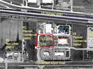
P.Z. 05-2009 River Crossing (Lot C, Holiday Inn & Suites): A request for an amendment to City of Chesterfield Ordinance Number 2469 for an increase in building height and maximum development square footage and a decrease in the openspace requirement for River Crossing Development, zoned "PC" Planned Commercial Development, located on the north side of Chesterfield Airport Road, at its intersection with Arnage, containing 15.841 acres of land. (17U520061, 17U520072, 17U240066, 17U240077, 17U240088, 17U520171, 17U520182, 17U520193)
ÂÂ
|  |
To view a larger image, click here |  |
Anyone interested in the proceedings will be given an opportunity to be heard. Copies of the request are available for review from the Department of Planning at Chesterfield City Hall, 690 Chesterfield Parkway West, weekdays between the hours of 8:30 a.m. and 4:30 p.m. If you should need additional information about this project, please contact Annissa McCaskill-Clay, Lead Senior Planner by telephone at 636-537-4747 or by email at amccaskill@chesterfield.mo.us.
CITY OF CHESTERFIELD
Maurice Hirsch, Chair,
Chesterfield Planning Commission
For information about this and other projects under review by the Department of Planning, please visit "Planning Projects" at www.Chesterfield.mo.us.
DESCRIPTION OF PROPERTY
A tract of land being part of Shares 1, 2, and 3 of the Partition of the Estate of Peter Steffan in US Survey 125 and 126, Township 45 North, Range 4 East, St. Louis County, Missouri and being further described as follows:
Beginning at the intersection of the East line of said Share 1 with the North line of Chesterfield Airport Road (Old Highway 40). 100 feet wide; thence along the North line of said Chesterfield Airport Road, South 89 degrees 36 minutes 00 seconds West, 773.26 feet to a point of the West line of said Share 3; thence along the West line of said Share 3, North 0 degrees 36 minutes 09 seconds East, 935.41 feet to a point on the South line of Missouri State Highway 40 TR, said point being perpendicular distant 125 feet South of the center line of said Missouri State Highway 40 TR; thence along the South line of said Missouri State Highway 40 TR, South 84 degrees 04 minutes 20 seconds East 776.30 feet to a point on the East line of said Share 1; thence along the East line of said Share 1, South 0 degrees 35 minutes 21 seconds West, 849.83 feet to a point of beginning and containing 15.841 acres according to survey made by the Clayton Engineering Company November 2000