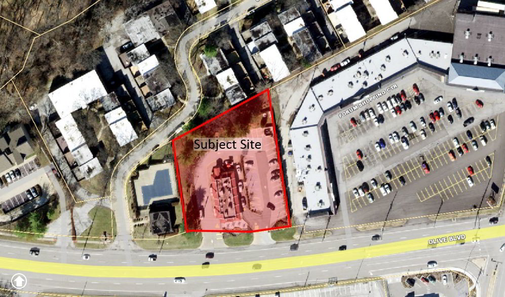
P.Z. 04-2019 13559 Olive Blvd (McDonald’s)
NOTICE IS HEREBY GIVEN that the Planning Commission of the City of Chesterfield will hold a Public Hearing on Monday, July 08, 2019 at 7:00 pm, in the Council Chambers at the City Hall, 690 Chesterfield Parkway West, Chesterfield, Missouri 63017.
Said Hearing will be as follows:
P.Z. 04-2019 13559 Olive Blvd (McDonald’s): A request for a zoning map amendment from a “C8” Planned Commercial District to a “PC” Planned Commercial District for a .86 tract of land located north of Olive Blvd., west of its intersection with North Woods Mill Rd. (16Q241471)
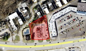
For a larger image of the site, please click HERE.
Anyone interested in the proceedings will be given an opportunity to be heard. Copies of the request are available for review in the Department of Planning and Development Services at Chesterfield City Hall, 690 Chesterfield Parkway West during weekdays between the hours of 8:30 a.m. and 4:30 p.m. If you should need additional information about this project, please contact Mr. Mike Knight, Planner, by telephone at 636-537-4736 or by email at JKnight@Chesterfield.MO.US
CITY OF CHESTERFIELD
Merrell Hansen, Chair
Chesterfield Planning Commission
PROPERTY DESCRIPTION
A tract of land being part of Lot 1, Share 1, Partition of Missouri Stevens Estate in U.S. Survey 207, Township 46 North, Range 5 East of the Fifth Principal Meridian, St. Louis County, Missouri, being more particularly described as follows:
Beginning at the point of intersection of the eastern line of Forum West Section One, as per plat recorded in Plat Book 126, Page 90 of the St. Louis County Records, with the northern right of way line of Olive Blvd.; thence along the eastern and southern lines of said Forum West Section One, North 9 degrees 27 minutes 41 seconds West 158.20 feet and North 62 degrees 25 minutes 09 seconds East 194.86 feet; thence leaving said lines of Forum West Section One, South 9 degrees 27 minutes 46 seconds East 241.67 feet to a point on the aforesaid right of way of Olive Blvd.; thence along said right of way line South 82 degrees 23 minutes 42 seconds West 7.08 feet to a point on a curve to the right, whose Chord bears North 83 degrees 9 minutes 27 seconds East 48.69 feet from the last described point; thence along the arc of said curve 48.70 feet; thence North 89 degrees 34 minutes 20 seconds West 125.61 feet; thence South 69 degrees 9 minutes 41 seconds West 5.85 feet to the point of beginning and containing 37,313 square feet or 0.85 acres more or less.
Exempting the following parcel; Commencing at the northwesterly corner of a tract described in Book 7755 Page 1660; Thence, S09 27'41"E 138.57 Feet; Thence N8O 32'19"E 15.59 Feet, to the point of beginning; Thence, N81 48'19"E 10.00 Feet; Thence, SO8 30'07"E 21.66 Feet; Thence S89 34'20"W, 10.13 Feet; Thence, NO8 30'07"W, 20.14 Feet; to the point of beginning. Containing 220 square feet, more or less.
Also exempting the following parcel; Commencing at the northwesterly corner of a tract described in Book 7755 Page 1660; Thence, N62 25'09"E, 37.14 Feet; Thence, S27 34'51"E, 26.44 Feet, to the point of Beginning; Thence, S46 28'39"E, 15.00 Feet; Thence, S43 31'21"W, 15.00 Feet; Thence, N46 28'39"W, 15.00 Feet; Thence, N43 31'21"E, 15.00 Feet; to the point of beginning. Containing 225 square feet, more or less.