P.Z. 12-2009 New Kinkead Estates (James and Suzanne Burnley)- SECOND HEARING
NOTICE IS HEREBY GIVEN that the Planning Commission of the City of Chesterfield will hold Public Hearings on Monday September 14, 2009, at 7:00 pm in the Council Chambers at the City Hall, 690 Chesterfield Parkway West, Chesterfield, Missouri 63017. Said hearing will be as follows:
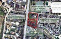
P.Z. 12-2009 New Kinkead Estates (James and Suzanne Burnley): A request for a new public hearing to amend the legal description for the change of zoning from an "R3" Residence District to an "R6A" Residence District for a 1.1 acre tract of land located at 1000 N. Woods Mill Road, ¼ mile south of the intersection of Woods Mill Road and Olive Boulevard. (16Q310021)
|  |
To view a larger image, click here. |  |
Anyone interested in the proceedings will be given an opportunity to be heard. Copies of the request are available for review in the Department of Planning at the Chesterfield City Hall, 690 Chesterfield Parkway West during weekdays between the hours of 8:30 a.m. and 4:30 p.m. If you should need additional information about this project, please contact Ms. Mara Perry, Senior Planner, by telephone at 636-537-4744 or by email at mperry@chesterfield.mo.us
CITY OF CHESTERFIELD
Maurice L. Hirsch, Jr., Chair
Chesterfield Planning Commission
Description of Property
Part of a tract of land, described in Book 8789 Page 1262 of the St. Louis County Records, being part of Lot 3 of "Kinkead Estate" in U.S. Survey 367, Township 45 North, Range 5 East in St. Louis County, Missouri, and described as follows:
Beginning at the intersection of the East line of Woods Mill Road, 60.00 feet wide, with the South line of property conveyed to Frederick O. Sahm and wife by Deed recorded in Book 2297, Page 469 of the St. Louis County Records, which is also the center line of Beck Drive a private street, 50 feet wide, established by instrument recorded in Book 2502 Page 53; thence along the centerline of Beck Drive South 82 degrees 45 minutes East, 191.65 feet to the Northwest corner of a 3.00 acre tract conveyed to Albert A. Weinrich and Wife by Deed recorded July 18, 1949, Daily No. 128; thence along the West line of said Weinrich tract, South 7 degrees 15 minutes West, 320.96 feet to a point; thence North 64 degrees 47 minutes West 177.51 feet to the East of said Woods Mill Road, 50 feet East of the center line of said Road; thence along the East line of said Woods Mill Road North 6 degrees 39 minutes east, 27.04 feet to a point; thence North 83 degrees 21 minutes West, 20.00 feet to the East line of said Woods Mill Road, 60.00 feet wide; thence along the East line of said Woods Mill Road North 6 degrees 39 minutes East, 239.39 feet to the point of beginning and containing 1.256 acres, more or less.