P.Z. 12-2017 15320 Conway Road (SMS Group, LLC)
NOTICE OF PUBLIC HEARING
CITY OF CHESTERFIELD
PLANNING COMMISSION
NOTICE IS HEREBY GIVEN that the Planning Commission of the City of Chesterfield will hold a Public Hearing on Monday, September 25, 2017 at 7:00 p.m. in the Council Chambers at Chesterfield City Hall, 690 Chesterfield Parkway West, Chesterfield Missouri 63017.
Said Hearing will be as follows:
P.Z. 12-2017 15320 Conway Road (SMS Group, LLC): A request for a zoning map amendment from the “R-3” Residence District to a “PC” Planned Commercial District for a 0.93 acre tract of located on the south side of Conway Road, approximately 500’ west of the intersection of Conway Road and Chesterfield Parkway (18S310348).
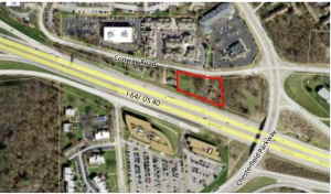
For a larger image of the site, please click HERE.
Anyone interested in the proceedings will be given an opportunity to be heard. Copies of the request are available for review in the Department of Planning & Development Services at Chesterfield City Hall, 690 Chesterfield Parkway West during weekdays between the hours of 8:30 a.m. and 4:30 p.m. If you should need additional information about this project, or for a list of requested uses, please contact Ms. Cassie Harashe, Project Planner, by telephone at 636-537-4745 or by email at CHarashe@chesterfield.mo.us
CITY OF CHESTERFIELD
Merrell Hansen, Chair
Chesterfield Planning Commission
PROPERTY DESCRIPTION
A tract of land being part in fractional Section 10, Township 45 North, Range 4 East of the Fifth Principal Meridian, City of Chesterfield, St. Louis County, Missouri, and being more particularly described as follows:
A tract of land described in deed recorded Book 1199 Page 392 of the St Louis County Records, and described as: Beginning at the Northwest corner of a tract of land conveyed to Mazie Moss Hord by deed recorded in Book 1199 Page 392 of the St Louis County Records; thence along the West line of property conveyed to Hord as aforesaid, South 4 degrees 35 minutes 48 seconds East 144.04 feet to the North line of Missouri State Highway No. 40 (Traffic Relief), 200 feet wide; thence along the North line of Highway No. 40, South 70 degrees 9 minutes 00 seconds East 311.93 feet; thence North 4 degrees 35 minutes 48 seconds West 216.76 feet to a point in the center line of Conway Road, 40 feet wide; thence along the center line of said road South 83 degrees 49 minutes 52 seconds West 58.97 feet and North 80 degrees 08 minutes 47 seconds West 232.36 feet to the point of beginning and containing 40,705 square feet or 0.93 acres more or less.