T.S.P. 30-2011 AT&T (16641 Old Chesterfield Road)
NOTICE OF PUBLIC HEARING
CITY OF CHESTERFIELD
PLANNING COMMISSION
NOTICE IS HEREBY GIVEN that the Planning Commission of the City of Chesterfield will hold a Public Hearing on Monday, September 26, 2011, at 6:30 p.m, in the Council Chambers at the City Hall, 690 Chesterfield Parkway West, Chesterfield, Missouri 63017.
Said hearing will be as follows:
T.S.P. 30-2011 AT&T (16641 Old Chesterfield Road): A request to obtain approval for a Telecommunication Facility Siting Permit for a collocation of additional antennas and equipment on an existing monopole in a "C7" General Extensive Commercial District - zoned property located on the north side of Old Chesterfield Road east of Baxter Road (17T310247).
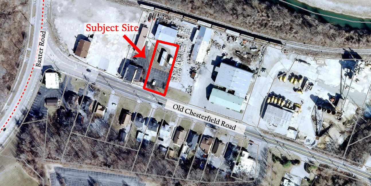
For a larger image of the site, please click HERE.
Anyone interested in the proceedings will be given an opportunity to be heard. Copies of the request are available for review in the Department of Planning and Public Works at Chesterfield City Hall, 690 Chesterfield Parkway West during weekdays between the hours of 8:30 a.m. and 4:30 p.m. If you should need additional information about this project, please contact Mr. Kristian Corbin, Project Planner, by telephone at 636-537-4743 or by email at kcorbin@chesterfield.mo.us
CITY OF CHESTERFIELD
Amy Nolan, Chair
Chesterfield Planning Commission
Description of Property
A tract of land in Lots 10, 11, and 12 of Burkhardt Subdivision in U.S. Survey 2031, Township 45 North, Range 4 Chesterfield, St. Louis County, Missouri and being more particularly as follows:
Beginning at an old iron pipe at the northeasterly corner of a 100 foot wide parcel, being part of the land of Charles W. Fawcett, Jr. Trustee, as recorded in Deed Book 9639, Page 1575, St. Louis County records; thence along the easterly line of said parcel, south 19 degrees 17 minutes 41 seconds west 127.66 feet to an iron rod (set): thence leaving said easterly line and defining the lease parcel herein described, north 70 degrees 42 minutes 19 seconds west 20.00 feet to an iron rod (set): thence north 19 degrees 17 minutes 41 seconds east 115.62 feet to an iron rod (set): thence north 70 degrees 47 minutes 00 seconds west 79.98 feet to an iron rod (set): thence south 19 degrees 13 minutes 00 seconds west 99.81 feet to an iron (set): thence north 70 degrees 47 minutes 00 seconds west 50.24 feet to an iron rod (set): on the westerly line of a 50 foot wide parcel being part of the aforesaid land of Fawcett; thence along said westerly line north 19 degrees 13 minutes 00 seconds east 168.94 feet to an iron rod (set): thence leaving said westerly line and defining the lease parcel herein described, south 70 degrees 47 minutes 00 seconds east 50.24 feet to an iron rod (set) on the easterly line of said 50 foot wide parcel; thence along said easterly line south 19 degrees 13 minutes 00 seconds west 57.12 feet to the northerly line south 70 degrees 47 minutes 00 seconds east 100.00 feet to the point of beginning of this description and containing 12,000 square feet more or less. Subject to all easements conditions and restrictions of record, if any.