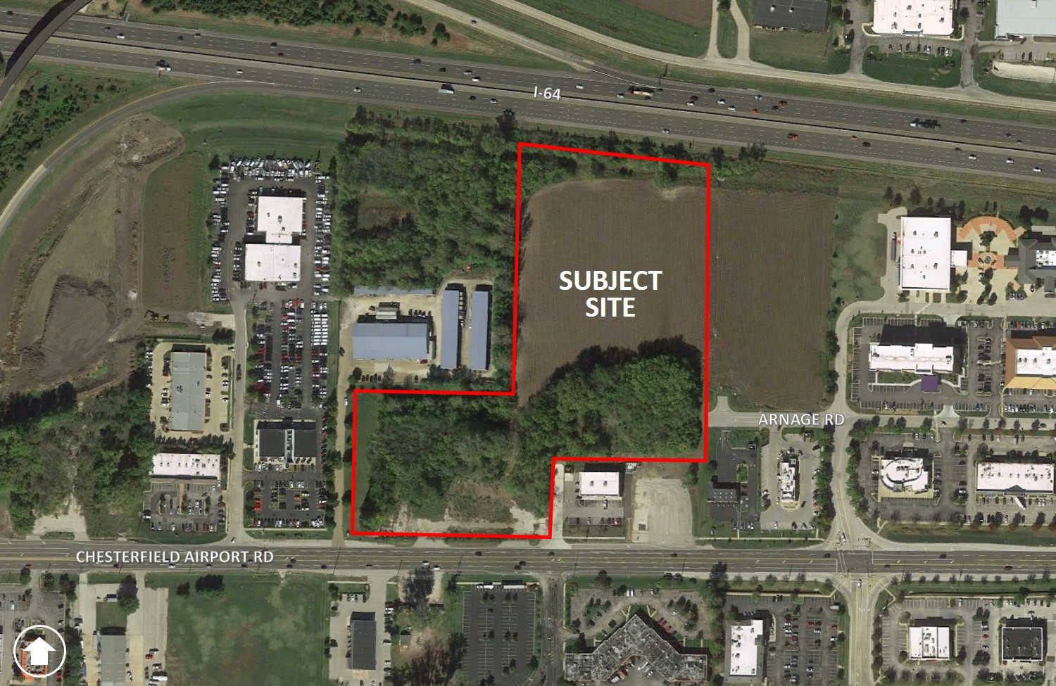
P.Z. 13-2019 84 Lumber, Adj. Lot 2 (17511 Chesterfield Airport Rd.)
NOTICE IS HEREBY GIVEN that the Planning Commission of the City of Chesterfield will hold a Public Hearing on Wednesday, October 16, 2019 at 7:00 p.m. in the Council Chambers at Chesterfield City Hall, 690 Chesterfield Parkway West, Chesterfield Missouri 63017.
Said Hearing will be as follows:
P.Z. 13-2019 84 Lumber, Adj. Lot 2 (17511 Chesterfield Airport Rd.): A request to amend Ordinance 2969 to establish new permitted uses and revise the development criteria for 13.023 acres of land within an existing “PC” Planned Commercial District located on the north side of Chesterfield Airport Road east of Long Road (17U510084).
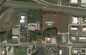
For a larger image of the site, please click HERE.
Anyone interested in the proceedings will be given an opportunity to be heard. Copies of the request are available for review in the Department of Planning & Development Services at Chesterfield City Hall, 690 Chesterfield Parkway West during weekdays between the hours of 8:30 a.m. and 4:30 p.m. If you should need additional information about this project, or for a list of requested uses, please contact Mr. Andrew Stanislav, Planner, by telephone at 636-537-4738 or by email at astanislav@chesterfield.mo.us.
CITY OF CHESTERFIELD
Merrell Hansen, Chair
Chesterfield Planning Commission
PROPERTY DESCRIPTION
A tract of land being Adjusted Lot 2 of the Boundary Adjustment Plat of 84 Lumber Subdivision as recorded in Plat Book 367 Page 350 of the St. Louis County Records, and part of U.S. Survey 125, located in Township 45 North, Range 4 East of the 5th Principal Meridian, City of Chesterfield, St. Louis County, Missouri, and being more particularly described as follows:
Beginning at the southwest corner of Chesterfield Airport Road 17505 as recorded in Plat Book 365 Page 150 of the St. Louis County records, said point being on the north right of way line of Chesterfield Airport Road, 100 feet wide; thence South 89 degrees 31 minutes 27 seconds West, along the north right of way line of said Airport Road, 520.40 feet, to the southeast corner of Lot 1 of above said 84 Lumber Subdivision; thence the following courses and distance along the east and south lines of Lot 1 of said 84 Lumber Subdivision: North 00 degrees 49 minutes 46 seconds East, 367.38 feet; North 89 degrees 31 minutes 24 seconds East 406.95 feet; and North 00 degrees 45 minutes 19 seconds East, 641.93 feet to the south right of way line of Interstate 64, variable width; thence South 84 degrees 19 minutes 27 seconds East, along the south line of said Interstate 64, 505.66 feet, to the west line of Chesterfield Commons Seven as recorded in Plat Book 359 Page 156 of the St. Louis County records; thence South 00 degrees 28 minutes 53 seconds West, along the west line of said Chesterfield Commons Seven, 754.45 feet; thence South 89 degrees 31 minutes 27 seconds West, along the north line of Outparcel 2 of said Chesterfield Commons Seven, and the north line of said Chesterfield Airport 17505, 395.35 feet, to the northwest corner of said Chesterfield Airport Road 17505; thence South 00 degrees 31 minutes 19 seconds West, along the West line of said Chesterfield Airport Road 17505, 200.56 feet; to the POINT OF BEGINNING. Containing 567,264 square feet or 13.023 acres, more or less, according to calculations performed by Stock & Associates Consulting Engineers, Inc. on May 3rd 2019.