P.Z. 10-2018 THF Chesterfield Development LLC (The Commons)
NOTICE OF PUBLIC HEARING
CITY OF CHESTERFIELD
PLANNING COMMISSION
NOTICE IS HEREBY GIVEN that the Planning Commission of the City of Chesterfield will hold a Public Hearing on Monday, October 22, 2018 at 7:00 p.m. in the Council Chambers at Chesterfield City Hall, 690 Chesterfield Parkway West, Chesterfield Missouri 63017.
Said Hearing will be as follows:
P.Z. 10-2018 THF Chesterfield Development LLC (The Commons): A request to amend Ordinance 2081 to modify the legal description and development conditions pertaining to the hours of operation for retail uses within an existing “C-8” Planned Commercial District located between US Highway 40/Interstate 64 and Edison Avenue and East of RHL Drive. (17T130133, 17T110212, 17U340155, 17U330091, 17U340078, 17T140341, 17U340089, 17U330123, 17U330101, 17U330112, 17U340090, 17U340100, 17U320102, 17T130210, 17U340111, 17U340144, 17T130144, 17T130155, 17T130166, 17T140132, 17T140143, 17U340067, 17T130188, 17T130089, 17T140187).
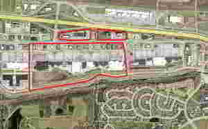
For a larger image of the site, please click HERE.
Anyone interested in the proceedings will be given an opportunity to be heard. Copies of the request are available for review in the Department of Planning and Development Services at Chesterfield City Hall, 690 Chesterfield Parkway West during weekdays between the hours of 8:30 a.m. and 4:30 p.m. If you should need additional information about this project or for a list of requested uses, please contact Ms. Cassie Harashe, Planner, by telephone at 636-537-4745 or by email at CHarashe@chesterfield.mo.us
CITY OF CHESTERFIELD
Merrell Hansen, Chair
Chesterfield Planning Commission
PROPERTY DESCRIPTION
A tract of land being a part of Lots 1, 2, 3 and 4 of the subdivision of Ludwell Bacons Estate, and part of Lots 1-10 of the Herman Ficke Estate Subdivision, in US Surveys 125 and 2031, and more recently described as Lots 1-5, 7 and 8 of Chesterfield Commons Subdivision recorded in Plat Book 848, pages 554-564, Township 45 North, Range 4 East, City of Chesterfield, St. Louis County, Missouri, said tract being further described as follows:
Beginning at a point located at the right of way intersection of the south right of way Chesterfield Airport Road and the west right of way of RHL Drive and running along Chesterfield Airport Road the following: N 89 degrees 35 minutes 06 seconds E for 229.87 feet; S 89 degrees 16 minutes 09 seconds E for 300.06 feet; S 86 degrees 36 minutes 03 seconds E for 120.27 feet; N 89 degrees 35 minutes 06 seconds E for 465.64 feet; N 00 degrees 24 minutes 54 seconds W for 8.00 feet; N 89 degrees 35 minutes 06 seconds E for 266.36 feet; N 88 degrees 26 minutes 21 seconds E for 300.06 feet; N 89 degrees 35 minutes 06 seconds E for 263.00 feet; S 86 degrees 36 minutes 00 seconds E for 120.27 feet; N 89 degrees 35 minutes 06 seconds E for 456.35 feet; N 00 degrees 24 minutes 54 seconds W for 8.00 feet; N 89 degrees 35 minutes 06 seconds E for 903.56 feet; S 86 degrees 36 minutes 13 seconds E for 120.35 feet; N 89 degrees 35 minutes 06 seconds E for 84.35 feet; N 89 degrees 35 minutes 16 seconds E for 213.41 feet; N 89 degrees 35 minutes 06 seconds E for 24.23 feet; N 00 degrees 24 minutes 54 seconds W for 8.00 feet; N 89 degrees 35 minutes 06 seconds E for 170.18 feet; thence leaving said right of way S 00 degrees 25 minutes 35 seconds E for 274.49 feet to a point; thence N 89 degrees 23 minutes 53 seconds E for 33.87 feet to a point; S 01 degrees 37 minutes 21 seconds W for 966.48 feet to a point on the south right of way of Edison Avenue; thence along Edison Avenue the following: S 81 degrees 50 minutes 20 seconds W for 626.18 feet; along a curve concave to the north having a radius of 630.00 feet, an arc of 249.73 feet and a chord of N 86 degrees 48 minutes 19 seconds W for 248.10 feet; N 75 degrees 26 minutes 57 seconds W for 192.15 feet; along a curve concave to the south having a radius of 570.00 feet, an arc of 457.10 feet and a chord of S 81 degrees 34 minutes 39 seconds W for 444.95 feet; S 58 degrees 36 minutes 17 seconds W for 188.91 feet; along a curve concave to the north having a radius of 630.00 feet, an arc of 232.73 feet and a chord of S 69 degrees 11 minutes 16 seconds W for 231.41 feet; S 79 degrees 46 minutes 13 seconds W for 1418.90 feet; S 81 degrees 29 minutes 05 seconds W for 804.00 feet to a point; thence leaving said right of way N 00 degrees 21 minutes 46 seconds E for 1854.62 feet to a point; thence along Chesterfield Airport Road N 89 degrees 35 minutes 06 seconds E for 5.51 feet to the point of beginning. Said tract contains 140.692 acres. The above described area contains acreage with the rights of way of Chesterfield Commons Drive, Edison Avenue and RHL Drive. The above described is not to be used for property conveyance. This description should be used to describe a tract of land located in C8 zoning district.
A tract of land being a part of Lots 1, 2, 3 and 4 of the subdivision of Ludwell Bacons Estate, and part of Lots 1-10 of the Herman Ficke Estate Subdivision, in US Surveys 125 and 2031, and more recently described as Lot 6 of Chesterfield Commons Subdivision Recorded in Plat Book 848, Pages 554-564, Township 45 North, Range 4 East, City of Chesterfield, St. Louis County, Missouri, said tract being further described as follows:
Beginning at a point located on the north right of way of Chesterfield Airport Road said point being the southwestmost corner of Lot 6 as shown on plat recorded in Plat Book 848, Pages 554-564; thence leaving said right of way the following: N 42 degrees 15 minutes 54 seconds W for 66.72 feet; N 05 degrees 53 minutes 06 seconds E for 173.86 feet; N 43 degrees 23 minutes 35 seconds E for 70.24 feet; N 80 degrees 53 minutes 31 seconds E for 812.67 feet; N 85 degrees 33 minutes 19 seconds E for 363.07 feet; S 84 degrees 06 minutes 54 seconds E for 174.63 feet; N 00 degrees 58 minutes 49 seconds E for 21.08 feet; S 84 degrees 06 minutes 54 seconds E for 827.17 feet; S 82 degrees 12 minutes 21 seconds E for 300.17 feet; S 84 degrees 06 minutes 54 seconds E for 116.61 feet; S 01 degrees 38 minutes 32 seconds W for 303.22 feet to a point located on the north right of way of Chesterfield Airport Road; thence along said right of way S 89 degrees 35 minutes 06 seconds W for 975.52 feet; N 86 degrees 36 minutes 09 seconds W for 120.33 feet; S 89 degrees 35 minutes 06 seconds W for 451.70 feet; S 00 degrees 24 minutes 54 seconds E for 8.00 feet; S 89 degrees 35 minutes 06 seconds W for 482.96 feet; N 89 degrees 16 minutes 09 seconds W for 84.32 feet; N 85 degrees 30 minutes 27 seconds W for 284.15 feet; S 89 degrees 35 minutes 06 seconds W for 189.42 feet to the point of beginning. Said tract contains 22.753 acres more or less and except a tract of land containing 2.646 acres as described on a plat entitled "Country Club Car Wash Express”. The above described area contains acreage with the rights of way of Chesterfield Commons Drive, Edison Avenue and RHL Drive. The above described is not to be used for property conveyance. This description should be used to describe a tract of land located in C8 zoning district.
Less and except a parcel of land as described; beginning at a point located on the north right of way of Chesterfield Airport Road N 00 degrees 24 minutes 54 seconds W for 438.27 feet to a point; thence S 84 degrees 06 minutes 54 seconds E for 163.06 feet to a point; thence N 00 degrees 58 minutes 49 seconds E for 21.08 feet to a point; thence S 84 degrees 06 minutes 54 seconds E for 105.04 feet to a point; thence S 00 degrees 24 minutes 54 seconds E for 429.92 feet to a point on the north right of way of Chesterfield Airport Road; thence along said right of way S 89 degrees 35 seconds 06 seconds W for 266.99 feet to the point of beginning. Said tract contains 2.646 acres more or less.