P.Z. 10-2010 Schoettler Village PEU (Mlake 5, LLC)
NOTICE OF PUBLIC HEARING
CITY OF CHESTERFIELD
PLANNING COMMISSION
NOTICE IS HEREBY GIVEN that the Planning Commission of the City of Chesterfield will hold a Public Hearing on Monday, November 8, 2010, at 7:00 PM, in the Council Chambers at the City Hall, 690 Chesterfield Parkway West, Chesterfield, Missouri 63017.
Said hearing will be as follows:
P.Z. 10-2010 Schoettler Village PEU (Mlake 5, LLC): A request for an amendment to St. Louis County Ordinance 6059 more specifically a modification to the density requirements of a Planned Environmental Unit in a "R1A" Residence District, "R2" Residence District, "R3" Residence District, "R6" Residence District, and a "R6A" Residence District of 158.2 acres in size and located along Schoettler Valley Drive at the north from US Highway 40/Interstate 64 southward to Squires Way Drive, including the subdivisions of Schoettler Valley Apartments, West Ridge Estates, Schoettler Valley Estates, Highcroft Ridge School, and Bridle Creek and all those lots within.
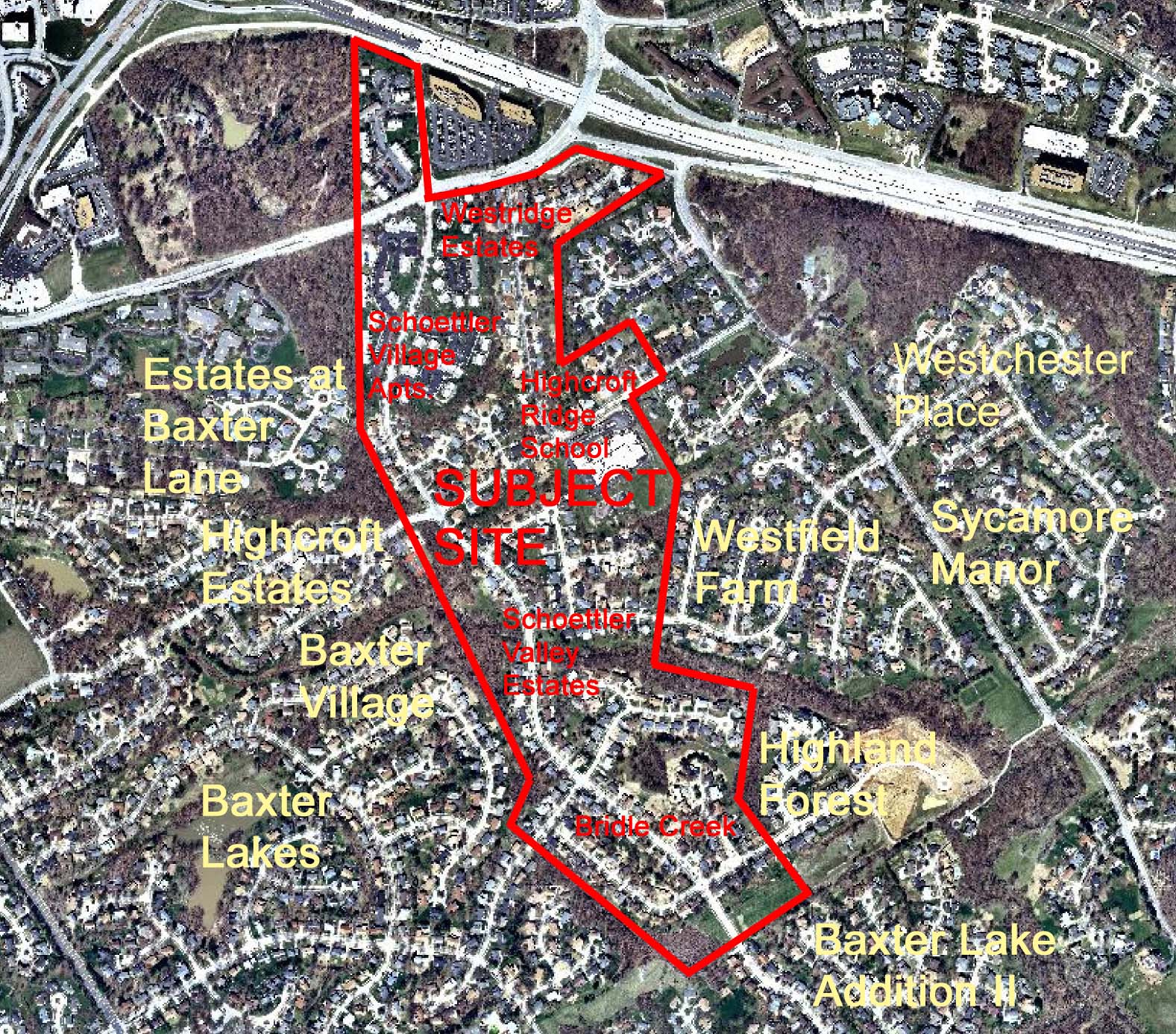
For a larger image of th site, please click here.
Anyone interested in the proceedings will be given an opportunity to be heard. Copies of the request are available for review in the Department of Planning and Public Works at the Chesterfield City Hall, 690 Chesterfield Parkway West during weekdays between the hours of 8:30 a.m. and 4:30 p.m. If you should need additional information about this project, please contact Mr. Shawn P. Seymour, Senior Planner, by telephone at 636-537-4741 or by email at sseymour@chesterfield.mo.us
CITY OF CHESTERFIELD
G. Elliot Grissom, Chair
Chesterfield Planning Commission
Description of Property
A tract of land in Sections 10 and 15, Township 45 North, Range 4 East, in St. Louis County, Missouri, and located as follows:
Starting at a point (Plot Point H) in the East line of U.S. Survey at its intersection with the South right-of-way line of U.S. Highway 40 as described in Book 6120, Page 329 of the St. Louis County Records; thence South 0 degrees 39 minutes West 1041.29 feet; thence South 0 degrees 59 minutes West 975.27 feet; thence South 0 degrees 59 minutes West 527.08 feet (Plot Point E); thence South 32 degrees 5 minutes East 428.70 feet (Plot Point C); thence South 32 degree 05 minutes East 1479.30 feet; thence South 11 degrees 36 minutes West 403.57 feet (Plot Point D); thence South 50 degrees 55 minutes East 1298.95 feet; thence North 58 degrees 41 minutes East 825.23 feet (Plot Point A); thence North 32 degrees 51 minutes West 628.16 feet; thence North 5 degrees 54 minutes East 757.05 feet; thence North 73 degrees 37 minutes West 676.62 feet (Plot Point B); thence North 10 degrees 02 minutes East 964.68 feet; thence North 31 degrees 38 minutes West 550.00 feet; thence North 31 degrees 38 minutes West 25.0 feet (Plot Point G); thence North 58 degrees 22 minutes East 214.25 feet; thence North 32 degrees 04 minutes West 404.77 feet; thence South 58 degrees 20 minutes West 387.06 feet; thence North 4 degrees 17 minutes West 602.75 feet (Plot Point I); thence North 58 degrees 20 minutes East 803.33 feet; thence North 17 degrees 24 minutes East 35.07 feet; thence North 72 degrees 26 minutes West 2.77 feet; thence North 74 degrees 05 minutes West 50.19 feet; thence North 62 degrees 54 minutes West 515.63 feet; thence North 69 degrees 33 minutes West 0.20 feet (Plot Point J); thence South 58 degrees 20 minutes West 312.20 feet; thence South 72 degrees 40 minutes West 267.83 feet; thence South 85 degrees 25 minutes West 378.29 feet; thence North 4 degrees 35 minutes West 629.71 feet (Plot Point K); thence North 83 degrees 52 minutes 10 seconds west 86.05 feet; thence North 72 degrees 41 minutes 45 seconds West 200.25 feet; thence North 66 degrees 32 minutes 51 seconds West 125.81 feet (Plot Point H) to the point of beginning.
Excepting Therefrom a 1.00 acre cemetery tract described as follows:
Beginning at a point which bears the following courses and distances from the intersection of the line between U.S. Surveys 1978 and 1890 with said East line of tract conveyed by Deed Book 678, Page 446; South 58 degrees 41 minutes West 825.23 feet to a point; thence North 50 degrees 55 minutes West 446.10 feet to a point; thence North 14 degrees 39 minutes East 801.89 feet to said point of beginning; thence North 14 degrees 38 minutes East 51.11 feet to a point; thence North 21 degrees 56 minutes West 267.24 feet to a point; thence North 80 degrees 51 minutes West 85.00 feet to a point; thence South 5 degrees 27 minutes West 280.34 feet to a point thence South 80 degrees 51 minutes East 200.00 feet to the point of beginning.
Containing 158.2 acres.