P.Z. 12-2016 Chesterfield Commerce Center (150 N. Eatherton Rd.)
NOTICE OF PUBLIC HEARING
CITY OF CHESTERFIELD
PLANNING COMMISSION
NOTICE IS HEREBY GIVEN that the Planning Commission of the City of Chesterfield will hold a Public Hearing on Monday, November 14, 2016 at 7:00 p.m. in the City Council Chambers at Chesterfield City Hall, 690 Chesterfield Parkway West, Chesterfield, Missouri 63017.
Said Hearing will be as follows:
P.Z. 12-2016 Chesterfield Commerce Center (150 N. Eatherton Rd.): A request for a zoning map amendment from an “NU” Non-Urban District to a “PI” Planned Industrial District for 10.80 acres located on the east side of N. Eatherton Rd., south of The Landings at Spirit Dr. (18W140020).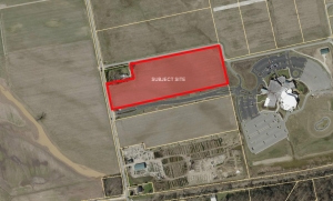
For a larger image of the site, please click HERE.
For a list of the Requested Uses, please click HERE.
Anyone interested in the proceedings will be given an opportunity to be heard. Copies of the request are available for review in the Department of Public Services at Chesterfield City Hall, 690 Chesterfield Parkway West during weekdays between the hours of 8:30 a.m. and 4:30 p.m. If you should need additional information about this project, please contact Mr. Justin Wyse, Senior Planner, by telephone at 636-537-4734 or by email at jwyse@chesterfield.mo.us
CITY OF CHESTERFIELD
Stanley Proctor, Chair
Chesterfield Planning Commission
PROPERTY DESCRIPTION
A tract of land as conveyed Virgil E. & Janet R. Moehsmer, Trust by instrument recorded in Book 20119, Page 570 of the St. Louis County records, located in U.S. Survey 362, Township 45 North, Range 3 East, City of Chesterfield, St. Louis County, Missouri being more particularly described as follows:
Beginning at a found Iron Rod located at the northwest corner of a tract of land as conveyed to St. Louis County, by instrument recorded in Book 17814, Page 1339 of above said records, said point also being located on the eastern right-of-way of Eatherton Road, variable width; thence along said right-of-way line, North 11 degrees 57 minutes 36 seconds West, 259.24 feet to the southwest corner of a tract of land as conveyed to Glen R. Hartog by instrument recorded in Book 7625, Page 452 of above said records, from which a found Iron Pipe lies 0.27 feet west; thence along the south of said Hartog tract, North 77 degrees 58 minutes 56 seconds East, 290.40 feet to the southeast corner of thereof, from which a found Iron Pipe lies 0.41 feet west; thence along the east line of said Hartog tract, North 11 degrees 57 minutes 36 seconds East, 150.00 feet the northeast corner thereof, from which a found Iron Pipe lies 0.46 feet west, said point also being located on the south line of a tract of land as conveyed to St. Louis County, by instrument recorded in Book 8889, Page 1550 of above said records; thence along said south line, North 78 degrees 00 minutes 00 seconds East, 959.92 to a found Stone located at the northeast corner of above said Moehsmer tract; thence along the east line of said Moeshmer tract, South 13 degrees 03 minutes 19 seconds East, 409.40 feet to a found Stone located at the northeast corner of a tract of land as conveyed to Windsor Crossing Community Church by instrument recorded in Book 17399, Page 4585 of above said records, thence along the north line of said Windsor Crossing Community Church tract and the north line of above said St. Louis County, tract recorded in Book 17814, Page 1339, South 78 degrees 00 minutes 00 seconds West, 1258.15 feet to the point of beginning containing 469,826 square feet or 10.786 acres more or less according to calculations performed by Stock & Associates Consulting Engineers, Inc on September 1, 2016.