P.Z. 11-2022 Estates at Fire Rock
NOTICE IS HEREBY GIVEN that the Planning Commission of the City of Chesterfield will hold a Public Hearing on Monday, November 14, 2022 at 7:00 p.m. in the Council Chambers at the City Hall, 690 Chesterfield Parkway West, Chesterfield, Missouri 63017.
Said Hearing will be as follows:
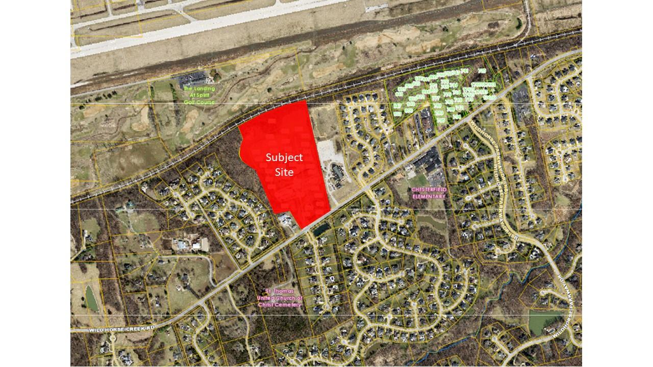
P.Z. 11-2022 Estates at Fire Rock: A request for a change in zoning from a Planned Unit Development (PUD) to E-1 AC Estate District for 35.0 acres located at 17803, 17815 and 17831 Wild Horse Creek Road (18V130099, 18V140065, & 18V140098).

For a larger image of the site, please click HERE.
Anyone interested in the proceedings will be given an opportunity to be heard. Copies of the request are available for review in the Department of Planning at Chesterfield City Hall, 690 Chesterfield Parkway West during weekdays between the hours of 8:30 a.m. and 4:30 p.m. If you should need additional information about this project, or for a list of requested uses, please contact Ms. Shilpi Bharti, Planner, by telephone at 636-537-4743 or by email at Sbharti@chesterfield.mo.us.
CITY OF CHESTERFIELD
Guy Tilman, Chair
Chesterfield Planning Commission
PROPERTY DESCRIPTION
A tract of land being all of Adjusted Parcel B of “Boundary Adjustment Plat of ‘A Tract of Land in U.S. Survey 102, Township 45 North – Range 3 East, St. Louis County, Missouri’” according to the plat thereof recorded in Plat Book 338 Page 96 of the St. Louis County, Missouri Records and part of Adjusted Tract A of “Boundary Adjustment Plat of ‘A Tract of Land in U.S. Survey 102, in Township 45 North – Range 3 East, St. Louis County, Missouri’” according to the plat thereof recorded in Plat Book 346 Page 353 of said records, all located in U.S. Survey 102, Township 45 North, Range 3 East, City of Chesterfield, St. Louis County, Missouri and being more particularly described as follows:
Beginning at a point being the southeast corner of above-said Adjusted Parcel B, said corner being the intersection of the north right-of-way line of Wild Horse Creek Road (width varies) and the northeast line of above-said U.S. Survey 102; thence along said north right-of-way line the following courses and distances: along a line being 30 feet north of and parallel to the centerline of said Wild Horse Creek Road, South 55°36'40" West, 375.00 feet; North 12°03'12" West, 16.22 feet; and along a line being 45 feet north of and parallel to said centerline, South 55°36'40" West, 124.28 feet to a point on the east line of a tract of land conveyed to Trustee of the Melvin L. Fick and Lillian K. Fick, Joint Revocable Living Trust Agreement by document recorded in Deed Book 7996 Page 1316 of the above-said records; thence leaving said right-of-way line and along the east and north lines of said Fick tract the following courses and distances: North 32°41'08" West, 308.72 feet and South 81°07'48" West, 226.56 feet to a point on the west line of above-said Adjusted Tract A; thence leaving said north line of Fick tract and along the west line of said Adjusted Tract A the following courses, distances and curves: North 22°46'12" West, 687.49 feet; North 57°30'33" West, 199.99 feet to a point of curvature; along a curve to the right with a radius of 175.00 feet, whose chord bears North 18°35’43” West, 219.85 feet, an arc distance of 237.71 feet to a point of tangency; North 20°19'07" East, 143.40 feet; and North 22°46'12" West, 200.68 feet to the northwest corner of said Adjusted Tract A, said point being on the south right-of-way line of Chicago, Rock Island and Pacific Railroad (100 feet wide); thence leaving said west line and along said south right-of-way line, along a curve to the right being non-tangential to the previous course, with a radius of 3519.70 feet, whose chord bears North 67°52'46" East, 889.74 feet, an arc distance of 892.13 feet to a point of tangency; thence continuing along said south right-of-way line, North 75°08'27" East, 176.95 feet to a point being the northeast corner of said Adjusted Tract A; thence leaving said south right-of-way line and along the east line of said Adjusted Tract A and its prolongation, being the east line of said Adjusted Parcel B, South 12°03'12" East, 1644.66 feet to the Point of Beginning and contains 1,527,037 square feet, or 35.056 acres, more or less according to survey performed by The Sterling Company during the month of August, 2021 under Order Number 20-07-232.