P.Z. 16-2009 17526, 17550, & 17536 Chesterfield Airport Road (St. Louis Family Church)
NOTICE OF PUBLIC HEARING
CITY OF CHESTERFIELD
PLANNING COMMISSION
NOTICE IS HEREBY GIVEN that the Planning Commission of the City of Chesterfield will hold a Public Hearing on Monday, December 14, 2009, at 7:00 PM, in the Council Chambers at the City Hall, 690 Chesterfield Parkway West, Chesterfield, Missouri 63017.
Said hearing will be as follows:
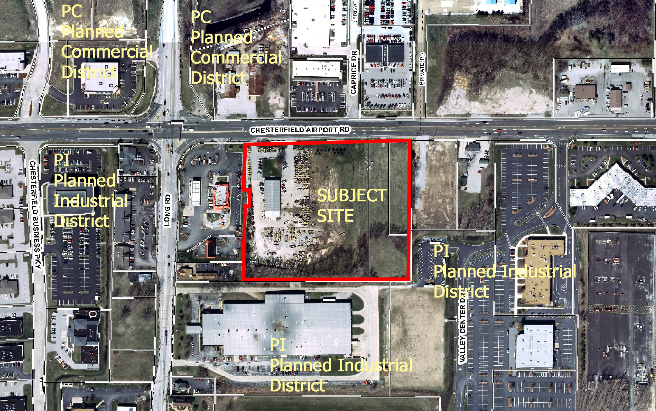
P.Z. 16-2009 17526, 17550, & 17536 Chesterfield Airport Road (St. Louis Family Church): A request for a change of zoning from a "C8" Planned Commercial District to a "PI" Planned Industrial District for a 8.318 acre tract of land located on the south side of Chesterfield Airport Road, east of the Chesterfield Airport Road and Long Road intersection (17U140131, 17U140102, & 17U140405).
For a list of the requested land uses, please contact the Project Planner.
To view an image of the site, click here.
Anyone interested in the proceedings will be given an opportunity to be heard. Copies of the request are available for review in the Department of Planning and Public Works at the Chesterfield City Hall, 690 Chesterfield Parkway West during weekdays between the hours of 8:30 a.m. and 4:30 p.m. If you should need additional information about this project, please contact Mr. Shawn P. Seymour, Project Planner, by telephone at 636-537-4741 or by email at sseymour@chesterfield.mo.us
CITY OF CHESTERFIELD
Maurice L. Hirsch, Jr., Chair
Chesterfield Planning Commission
Description of Property
A tract of land being part of Lot 4 of "A Subdivision of the West half of U.S. Survey 126," Township 45 North - Range 4 East, St. Louis County, Missouri and being more particularly described as:
Beginning at the Northwest corner of property described in deed to Junior G. Kool and wife recorded in Book 7086 page 1129 of the St. Louis County records; said point being also the Northeast corner of "Steve W. Wallace Subdivision," a subdivision according to the plat thereof recorded in Plat Book 345 page 701 of the St. Louis County records, and being also a point in the South line of Chesterfield Airport Road, 100 feet wide; thence Eastwardly along said South line of Chesterfield Airport Road, being also along the North line of said Kool property and along the North line of property described in deed to Craig Kool and wife recorded in Book 12463 page 814 of the St. Louis County records, North 89 degrees 35 minutes 24 seconds East 664.00 feet to the Northwest corner of property described in deed to Rhodes Development Co, LLC recorded in Book 17621 page 4668 of the St. Louis County records; said point being also a point in the East line of aforesaid Lot 4 of "A Subdivision of the West half of U.S. Survey 126"; thence Southwardly along said East line of Lot 4, being also along said West line of the Rhodes Development Co, LLC property and along the boundary line of property described in deed to St. Louis Family Church, Inc. recorded in Book 11893 page 1782 of the St. Louis County records, South 0 degrees 34 minutes 26 seconds West 546.09 feet to a point in said last mentioned boundary line; said St. Louis Family Church, Inc. property being shown as Adjusted Parcel Two on "A Boundary Adjustment Plat of Tracts of Land being part of Share 7 of the Peter Steffan Estate and part of Lot 4 of A Subdivision of the West half of U.S. Survey 126, Township 45 North - Range 4 East, St. Louis County, Missouri," according to the plat thereof recorded in Plat Book 346 pages 760 and 761 of the St. Louis County records; thence Westwardly along the North line of Adjusted Parcel Two and Adjusted Parcel One of said Boundary Adjustment Plat South 89 degrees 35 minutes 24 seconds West 667.91 feet to the Southeast corner of property described in deed to McCarthy LLC d/b/a Valley Farmers Market recorded in Book 16541 page 866 of the St. Louis County records; said point being also the Southwest corner of aforementioned Junior G. Kool and wife property; thence Northwardly along the East line of said McCarthy LLC d/b/a Valley Farmers Market property and the East line of aforementioned "Steve W. Wallace Subdivision," being also along the West line of said last mentioned Kool property the following courses and distances: North 1 degree 23 minutes 36 seconds East 296.29 feet, North 89 degrees 33 minutes 58 seconds East 15.40 feet, North 1 degree 23 minutes 36 seconds East 62.00 feet, South 89 degrees 33 minutes 58 seconds West 19.30 feet and North 1 degree 23 minutes 36 seconds East 188.00 feet to the point of beginning and containing 8.318 acres according to a survey by Volz Incorporated dated September 18, 2009.
ÂÂ