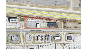
P.Z. 10-2015 Kemp Auto Museum (16955 Chesterfield Airport Road)
NOTICE OF PUBLIC HEARING
CITY OF CHESTERFIELD
PLANNING COMMISSION
NOTICE IS HEREBY GIVEN that the Planning Commission of the City of Chesterfield will hold a Public Hearing on November 23, 2015 at 7:00 p.m. in the City Council Chambers at Chesterfield City Hall, 690 Chesterfield Parkway West, Chesterfield, Missouri 63017.
Said Hearing will be as follows:
P.Z. 10-2015 Kemp Auto Museum (16955 Chesterfield Airport Rd.): A request for a zoning map amendment from a “PC” Planned Commercial District with a “MAA” Museum and Arts Overlay District to the new “PC” Planned Commercial District for a 5.104 acre tract located northeast of the intersection of Chesterfield Airport Road and Chesterfield Commons Drive (17T140211).
REQUESTED USES:
- Administrative offices for educational or religious institutions
- Animal grooming service
- Art gallery
- Art studio
- Auditorium
- Automobile dealership
- Automotive retail supply
- Bakery
- Banquet facility
- Bar
- Barber or beauty shop
- Bowling center
- Brewpub
- Broadcasting studio
- Church and other places of worship
- Club
- Coffee shop
- College/university
- Commercial service facility
- Community Center
- Day care center
- Drug store and pharmacy, with drive-thru
- Dry cleaning establishment
- Filling station and convenience store with pump stations
- Film drop-off and pick up stations
- Financial Institution, drive-thru
- Grocery-community
- Grocery-neighborhood
- Gymnasium
- Hospital
- Hotel and motel
- Hotel and motel-extended stay
- Kindergarten or nursery school
- Library
- Museum
- Newspaper stand
- Nursing home
- Office-dental
- Office-general
- Office-medical
- Oil change facility
- Postal stations
- Professional and technical service facility
- Public building facilities owned or leased by the City of Chesterfield
- Public safety facility
- Reading room
- Recreation facility
- Research laboratory & facility
- Restaurant-fast food
- Restaurant-sit down
- Restaurant-take out
- Retail sales establishment-community
- Retail sales establishment-neighborhood
- Specialized private school
- Tackle and bait shop
- Telecommunications structure
- Telecommunications tower or facility
- Theatre, indoor
- Vehicle repair and service facility
- Veterinary clinic
- Vocational school
Anyone interested in the proceedings will be given an opportunity to be heard. Copies of the request are available for review in the Department of Public Services at Chesterfield City Hall, 690 Chesterfield Parkway West during weekdays between the hours of 8:30 a.m. and 4:30 p.m. If you should need additional information about this project, please contact Mr. John Boyer, Senior Planner, by telephone at 636-537-4734 or by email at jboyer@chesterfield.mo.us
CITY OF CHESTERFIELD
Stanley Proctor, Chair
Chesterfield Planning Commission
PROPERTY DESCRIPTION
A tract of land being part of Adjusted New Parcel 2 of the Boundary Adjustment Plat, recorded in Plat Book 350 Page 81, in U.S. Survey 2031, Township 45 North Range 4 East, City of Chesterfield, St. Louis County, Missouri and being particularly described as follows:
Beginning at the southwest corner of said adjusted new parcel 2, said beginning point being also a point on the north line of Chesterfield Airport Road, of varying width; thence, northwardly along the west line of said adjusted new parcel 2, North 12 Degree 42 Minutes 40 Seconds West 26.61 feet, North 02 Degree 08 Minutes 554 Seconds West 84.73 feet and North 01 Degree 38 Minutes 32 Seconds East 194.51 feet to a point on the south line of Interstate Highway 64, of varying width; thence eastwardly along said south line, South 84 Degrees 06 Minutes 54 Seconds East 863.23 feet to a point; thence South 00 Degrees 25 Minutes 29 Seconds East 210.35 feet to a point on the aforesaid north line of Chesterfield Airport Road, of varying width; thence westwardly along said north line South 89 Degrees 35 Minutes 06 Seconds West 856.80 feet to the point of beginning and containing 5.104 acres according to calculations by Volz, Inc. during February 2003.