P.Z. 15-2019 Wiegand Studio (Wiegand Foundation)
NOTICE IS HEREBY GIVEN that the Planning Commission of the City of Chesterfield will hold a Public Hearing on Monday, November 25, 2019 at 7:00 p.m. in the Council Chambers at Chesterfield City Hall, 690 Chesterfield Parkway West, Chesterfield Missouri 63017.
Said Hearing will be as follows:
P.Z. 15-2019 Wiegand Studio (Wiegand Foundation): A request for a zoning map amendment from the “NU” Non-Urban District and “C-3” Shopping District to the “PC” Planned Commercial District with an existing “H” Historic Designation to remain for two tracts of land totaling 2.82 acres located on the east side of Baxter Road at its intersection with Edison Avenue (17T220942, 17T310335).
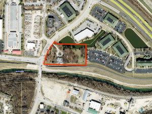
For a larger image of the site, please click HERE.
Anyone interested in the proceedings will be given an opportunity to be heard. Copies of the request are available for review in the Department of Planning & Development Services at Chesterfield City Hall, 690 Chesterfield Parkway West during weekdays between the hours of 8:30 a.m. and 4:30 p.m. If you should need additional information about this project, or for a list of requested uses, please contact Mr. Andrew Stanislav, Planner, by telephone at 636-537-4738 or by email at astanislav@chesterfield.mo.us.
CITY OF CHESTERFIELD
Merrell Hansen, Chair
Chesterfield Planning Commission
PROPERTY DESCRIPTION
Parcel 1: A tract of land in U.S. Survey 2031 Township 45 North, Range 4 East and described as follows:
Beginning at the intersection of the center line of Chicago, Rock Island and Pacific Railroad right of way, with the center line of a County Road, 60 feet wide established by Deed recorded in Book 1434, Page 260 of the St. Louis County Records, thence North 3 degrees 30 minutes East 186.20 feet and South 89 degrees 35 minutes 00 seconds East 163 feet to the Southwest corner and the point of beginning of the property herein described, thence North 13 degrees 39 minutes 03 seconds East along the center line of a private road, 155.19 feet, thence North 0 degrees 02 minutes 23 seconds West 84.33 feet, thence South 88 degrees 57 minutes 50 seconds East 359.77 feet, thence South 01 degrees 02 minutes 10 seconds West 235.79 feet, thence North 88 degrees 57 minutes 50 seconds West 392.20 feet to the place of beginning.
AND
Parcel 2: A tract of land located in U.S. Survey 2031, Township 45 North, Range 4 East and being more particularly described as follows:
Beginning at the Southwest property corner of a tract of land conveyed to Don F. Wiegand by deed recorded in Deed Book 8234, Page 1325 of the St. Louis County Records; thence South 88 degrees 57 minutes 50 seconds East along the South line of the aforesaid Wiegand tract a distance of 392.20 feet to a point, said point being the Southeast property corner of the aforesaid Wiegand tract; thence departing last said South line, South 01 degrees 02 minutes 10 seconds West 20.00 feet, thence North 88 degrees 57 minutes 50 seconds West 515.58 feet to a point; said point being on the eastern right-of-way line of Baxter Road, 82 feet wide; thence, following said eastern right-of-way line of Baxter Road, on a curve to the right whose radius point bears South 81 degrees 52 minutes 32 seconds East 534.00 feet from the last mentioned point, a distance of 321.25 feet to a point; thence leaving said eastern right-of-way line South 36 degrees 59 minutes 38 seconds East 41.36 feet to a point; said point being the Northwest corner of the aforementioned property; thence South 00 degrees 02 minutes 23 seconds West 84.33 feet to a point; thence South 13 degrees 39 minutes 03 seconds West 155.19 feet to the point of beginning.