P.Z. 14-2017 Larry Enterprises-Lynch Hummer (17401 N Outer 40 Rd) Ordinance Amendment
NOTICE OF PUBLIC HEARING
CITY OF CHESTERFIELD
PLANNING COMMISSION
NOTICE IS HEREBY GIVEN that the Planning Commission of the City of Chesterfield will hold a Public Hearing on Monday, November 27, 2017 at 7:00 p.m. in the Council Chambers at Chesterfield City Hall, 690 Chesterfield Parkway West, Chesterfield Missouri 63017.
Said Hearing will be as follows:
P.Z. 14-2017 Larry Enterprises-Lynch Hummer (17401 N Outer 40 Rd) Ordinance Amendment: A request to amend the legal description and development conditions of an existing “PI” Planned Industrial District in Ordinance #2055, for a 15.4 acre tract of land located north of Highway 40/Interstate 64, west of Boone’s Crossing (17U610139, 17U520258, 17U520269).
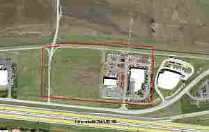
For a larger image of the site, please click HERE.
REQUESTED USES:
For a list of the Requested Uses, please click HERE.
Anyone interested in the proceedings will be given an opportunity to be heard. Copies of the request are available for review in the Department of Planning & Development Services at Chesterfield City Hall, 690 Chesterfield Parkway West during weekdays between the hours of 8:30 a.m. and 4:30 p.m. If you should need additional information about this project, please contact Ms. Cecilia Dvorak, Project Planner, by telephone at 636-537-4738 or by email at cdvorak@chesterfield.mo.us
CITY OF CHESTERFIELD
Merrell Hansen, Chair
Chesterfield Planning Commission
PROPERTY DESCRIPTION
A tract of land being Lot B of “Larry Enterprises and Lynch Hummer Subdivision” according to the plat thereof recorded in Plat Book 352, Page 135, and Parcels 1 and 2 of the “Lot Split Plat of Adjusted Lot A1 of the Boundary Adjustment Plat of Lot 2 of Amended Outdoor Equipment Subdivision and Lot A1 of the Resubdivision of Larry Enterprises and Lynch Hummer, PB 364, PG 369” a subdivision filed for record in Plat Book 365, Page 262 of the St. Louis County Records, located in U.S. Survey 125, Township 45 North, Range 4 East of the Fifth Principal Meridian, City of Chesterfield, St. Louis County, Missouri, being more particularly described as follows:
Beginning at the southeast corner of above said Lot B, said point also being located on the north right-of-way line of North Outer 40 Road, variable width; thence along said right-of-way line the following courses and distances: South 87 degrees 59 minutes 38 seconds West, 102.27 feet; North 85 degrees 17 minutes 37 seconds West, 978.82 feet and North 84 degrees 06 minutes 40 seconds West, 86.13 feet to the southwest corner of above said Parcel 2 of the Lot Split Plat recorded in Plat Book 365, Page 262; thence along the west line of said Parcel 2, North 00 degrees 33 minutes 56 seconds East, 509.16 feet to the northwest corner thereof; thence along the north, west and north lines of said Parcel 2 and Parcel 1 and above said Lot B of the “Larry Enterprises and Lynch Hummer Subdivision” according to the plat thereof recorded in Plat Book 352, Page 135, the following courses and distances: North 85 degrees 06 minutes 10 seconds East, 125.05 feet; South 89 degrees 15 minutes 32 seconds East, 51.19 feet; North 00 degrees 34 minutes 00 seconds East, 34.93 feet and South 88 degrees 08 minutes 08 seconds East, 488.67 feet to the northeast corner of the aforesaid Parcel 1 being on the western line of the aforesaid Lot B; thence crossing said Lot B, South 88 degrees 09 minutes 08 seconds East, 37.81 feet and South 84 degrees 53 minutes 54 seconds East, 461.24 feet to the east line of said Lot B; thence along said east line, South 00 degrees 19 minutes 57 seconds West, 581.52 feet to the Point of Beginning and containing 672,883 square feet or 15.447 acres more or less according to calculations performed by Stock & Associates Consulting Engineers, Inc on March 13, 2017.