P.Z. 15-2017 MPD Investments (14781 N Outer 40 Rd) Ordinance Amendment
NOTICE OF PUBLIC HEARING
CITY OF CHESTERFIELD
PLANNING COMMISSION
NOTICE IS HEREBY GIVEN that the Planning Commission of the City of Chesterfield will hold a Public Hearing on Monday, November 27, 2017 at 7:00 p.m. in the Council Chambers at Chesterfield City Hall, 690 Chesterfield Parkway West, Chesterfield Missouri 63017.
Said Hearing will be as follows:
P.Z. 15-2017 MPD Investments (14781 N Outer 40 Rd) Ordinance Amendment: A request to amend the legal description and development conditions of an existing “PI” Planned Industrial District in Ordinance #2411, for an 8.3 acre tract of land located north of Highway 40/Interstate 64, west of Boone’s Crossing (17U520269, 17U520247, 17U520148)
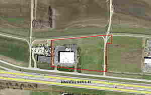
For a larger image of the site, please click HERE.
Anyone interested in the proceedings will be given an opportunity to be heard. Copies of the request are available for review in the Department of Planning & Development Services at Chesterfield City Hall, 690 Chesterfield Parkway West during weekdays between the hours of 8:30 a.m. and 4:30 p.m. If you should need additional information about this project, or for a list of requested uses, please contact Ms. Cecilia Dvorak, Project Planner, by telephone at 636-537-4738 or by email at cdvorak@chesterfield.mo.us
CITY OF CHESTERFIELD
Merrell Hansen, Chair
Chesterfield Planning Commission
PROPERTY DESCRIPTION
A tract of land being Lot 1 and Lot 2 of Amended Outdoor Equipment Subdivision as recorded in Plat Book 353, Page 948 of the St. Louis County Records, located in U.S. Survey 125, Township 45 North, Range 4 East of the 5th Principal Meridian, City of Chesterfield, St. Louis County, Missouri and being more particularly described as follows:
BEGINNING at the Southeasterly corner of Lot 2 of above said Amended Outdoor Equipment Subdivision, said point also being in the Northerly right-of-way line of Missouri Interstate Highway 64 / Missouri State Highway 40-61, thence along last said right-of-way line North 84 degrees 06 minutes 40 seconds West 776.15 feet to the Southwesterly corner of Lot 1 of above said Amended Outdoor Equipment Subdivision, thence along the Westerly line of above said Lot 1 North 00 degrees 34 minutes 00 seconds East 379.44 feet to the Northwesterly corner of above said Lot 1, thence along the Northerly line of above said Lot 1 and Lot 2 the following courses and distances: North 85 degrees 06 minutes 10 seconds 815.22 feet and South 89 degrees 15 minutes 32 seconds East 51.19 feet to the Northeasterly corner of above said Lot 2, said point also being in the Westerly line of Lot A of Larry Enterprises and Lynch Hummer Subdivision as recorded in Plat Book 352, Page 135 of the above said Records, thence along last said Westerly line the following courses and distances: South 00 degrees 34 minutes 00 seconds West 153.21 feet; South 89 degrees 34 minutes 43 seconds West 89.92 feet; and South 00 degrees 34 minutes 00 seconds West 374.14 feet to the POINT OF BEGINNING, and containing 363,394 square feet or 8.342 acres, more or less, according to calculations by Stock and Associates Consulting Engineers, Inc. on April 25, 2007.