P.Z. 14-2016 18331, 18333 & 18335 Chesterfield Airport Rd. (LSL I, LLC and LSLII, LLC.)
NOTICE OF PUBLIC HEARING
CITY OF CHESTERFIELD
PLANNING COMMISSION
CITY OF CHESTERFIELD
PLANNING COMMISSION
NOTICE IS HEREBY GIVEN that the Planning Commission of the City of Chesterfield will hold a Public Hearing on December 12, 2016 at 7:00 p.m. in the City Council Chambers at Chesterfield City Hall, 690 Chesterfield Parkway West, Chesterfield, Missouri 63017.
Said Hearing will be as follows:
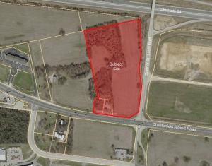
P.Z. 14-2016 18331, 18333 & 18335 Chesterfield Airport Rd. (LSL I, LLC and LSLII, LLC.): A request for a zoning map amendment from an “M3” Planned Industrial District to a “PC” Planned Commercial District for a 16.0 acre area of land at 18331, 18333 and 18335 Chesterfield Airport Road, located at the northwest side of the intersection of Chesterfield Airport Road and Spirit of St. Louis Boulevard. (17V410060, 17V410026 and 17V410037).
For a larger image of the site, please click HERE.
For a list of the Requested Uses, please click HERE.
Anyone interested in the proceedings will be given an opportunity to be heard. Copies of the request are available for review in the Department of Public Services at Chesterfield City Hall, 690 Chesterfield Parkway West during weekdays between the hours of 8:30 a.m. and 4:30 p.m. If you should need additional information about this project, please contact Mr. Justin Wyse, Senior Planner, by telephone at 636-537-4734 or by email at jwyse@chesterfield.mo.us
CITY OF CHESTERFIELD
Stanley Proctor, Chair
Chesterfield Planning Commission
PROPERTY DESCRIPTION
Parcel 1
A tract of land, being part of Lots 5 and 6 of the subdivision of R.H. Stevens Farm according to the plat thereof recorded in Plat Book 7, Page 37 of the St. Louis City, former County, records, and being part of U.S. Surveys 102 and 122, Township 45 North, Range 3 East of the fifth principal meridian in St. Louis County, Missouri, being also the 29.605 acre tract described in instrument recorded in Book 2898, Page 144 of the St. Louis County, Missouri records excepting therefrom that part conveyed to St. Louis County, Missouri by instrument recorded in Book 6249, Page 556, also excepting therefrom that part taken by the State of Missouri by Suit #290860, the Report of Commissioners is recorded in Book 6343, Pages 824 thru 871 of the St. Louis County, Missouri records, and being more particularly described as follows: beginning at the northwestern corner of said 29.605 acre tract, being a point on the south line of Lot 3 of the Nicholas Mueller Estate, distant North 77 degrees 35 minutes 54 seconds Rast 1494.83 feet (by deed) from the southwest corner of said Lot 3; thence along the north line of said 29.605 acre tract, the south line of said Lot 3, and the south line of Lots 3 and 2 of the subdivision of Lots 1 and 2 of the partition of the Nicholas Mueller Estate, North 77 degrees 35 minutes 54 seconds East 723.04 feet to the northwest corner of said part taken by the State of Missouri, and described in Book 6343, Page 838 and 839 of said St. Louis County records; thence along the western line of said part taken South 0 degrees 18 minutes 39 seconds East 391.87 feet; South 4 degrees 48 minutes 31 seconds West 200.13 feet; South 3 degrees 12 minutes 29 seconds East 253.18 feet; South 5 degrees 52 minutes 56 seconds West 355.00 feet; and South 50 degrees 06 minutes 45 seconds West 128.92 feet to the northern line of Chesterfield Airport Road, 100 feet wide, (traffic relief highway No. 40), being also a point on the boundary of said 29.605 acre tract; thence along said northern line North 83 degrees 41 minutes West 172.40 feet to the southeastern corner of the 0.508 acre tract described in said Book 2898, Page 144; thence along the eastern line of said 0.508 acre tract North 4 degrees 57 minutes West 198.83 feet to the northeastern corner of said 0.508 acre tract; thence along the northern line of said 0.508 acre tract and the northern line of a 0.535 acre tract described in said Book 2898, Page 144 North 83 degrees 41 minutes West 185.55 feet to the corner of said 29.605 acre tract; thence North 12 degrees 32 minutes 53 seconds West 908.83 feet back to the point of beginning.
Parcel 2
Part of Lot 6 of the subdivision of R.H. Stevens Farm in U.S. Survey 102 Township 45 North Range 3 East, according to the plat thereof recorded in Plat Book 7, Page 37 of the records of the City (former County) of St. Louis, Missouri and described as: beginning at a point in the north line of traffic relief highway #40, 100 feet wide, which point bears North 83 degrees 26 minutes West 1737.78 feet from the southeast corner of a 29.612 acre tract first described in deed to Ann C. Albrecht by deed recorded in Book 2890, Page 388, thence North 4 degrees 42 minutes West 198.83 feet to a point, thence North 83 degrees 26 minutes West 94.14 feet to the northeast corner of a 0.535 acre tract secondly described in deed to Ann C. Albrecht by deed recorded in Book 2890, Page 388, thence along the East line of said tract, South 6 degrees 34 minutes West 195 feet to the southeast corner thereof in the north line of traffic relief highway #40, thence South 83 degrees 26 minutes East 133 feet along the north line of said highway to the point of beginning, as per survey by Clayton Surveying and Engineering Company on January 8, 1952.
Parcel 3
Part of Lot 6 of subdivision of R.H. Stevens Farm in U.S. Survey 102 Township 45 North Range 3 East, according to the plat thereof recorded in Plat Book 7, Page 37 of the St. Louis City (former County), Missouri records and described as: beginning at a point in the north line of traffic relief highway #40, 100 feet wide, which point bears North 83 degrees 26 minutes West 1870.78 feet from the southeast corner of a 29.612 acre tract firstly described in deed to Ann C. Albrecht by deed recorded in Book 2890, Page 388, St. Louis County records, being also the southwest corner of a 0.508 acre tract conveyed to Edwin F. Albrecht and Wife, et al, by deed recorded in Book 2900, Page 325 St. Louis County records, thence along the north line of said highway north 83 degrees 26 minutes West 18 feet to a point of tangency of a curve to the right having a radius if 3901.54 feet, thence continuing along said curve a distance of 102 feet to a point being a corner of a 29.610 acre tract conveyed to George W. Albrecht and Wife by deed recorded in Book 2848, Page 472, St. Louis County records, thence along the property line of said George W. Albrecht and Wife North 6 degrees 34 minutes East 193.72 feet to another corner thereof and South 83 degrees 26 minutes East 120 feet to the northwest corner of aforesaid 0.508 acre tract conveyed to Edwin F. Albrecht and wife, et al, thence along the west line of said .508 acre tract South 6 degrees 34 minutes West 195 feet to the point of beginning, as per survey executed by Clayton Surveying and Engineering Company on January 8, 1952.