P.Z. 17-2019 Koester Acres
NOTICE IS HEREBY GIVEN that the Planning Commission of the City of Chesterfield will hold a Public Hearing on Monday, January 13, 2020 at 7:00 p.m. in the Council Chambers at Chesterfield City Hall, 690 Chesterfield Parkway West, Chesterfield Missouri 63017.
Said Hearing will be as follows:
P.Z. 17-2019 Koester Acres: A change in zoning from “FPNU” Floodplain Non-Urban District to “AG” Agricultural District for two parcels of land totaling 89.21 acres in size at 17485A and 17509 N. Outer 40 Road (17U540036 & 16U210024).
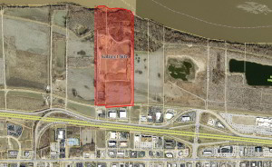
For a larger image of the site, please click HERE.
Anyone interested in the proceedings will be given an opportunity to be heard. Copies of the request are available for review in the Department of Planning & Development Services at Chesterfield City Hall, 690 Chesterfield Parkway West during weekdays between the hours of 8:30 a.m. and 4:30 p.m. If you should need additional information about this project, or for a list of requested uses, please contact Ms. Annisa Kumerow, Planner, by telephone at 636-537-4743 or by email at akumerow@chesterfield.mo.us.
CITY OF CHESTERFIELD
Merrell Hansen, Chair
Chesterfield Planning Commission
PROPERTY DESCRIPTION
A tract of land being Lot 2 of Koester Acres, a subdivision recorded in Plat Book 207, Page 1 of the St. Louis County Records, and Part of Shares 1, 2 & 3 of the subdivision of the estate of Peter Steffan, located in U.S. Survey 125, Township 45 North, Range 4 East in St. Louis County, Missouri, being more particularly described as follows:
Beginning at a point being the Southwest Corner of Lot 2 of Koester Acres, thence North 00 degrees 34 minutes 14 seconds East, 3125.40 feet to a point; thence North 82 degrees 03 minutes 28 seconds East, 178.03 feet to a point; thence South 85 degrees 48 minutes 21 seconds East, 80.10 feet to a point; thence South 52 degrees 35 minutes 01 seconds East, 62.10 feet to a point being the Northeast Corner of Lot 2; thence South 52 degrees 35 minutes 01 seconds East, 62.32 feet to a point; thence South 79 degrees 45 minutes 20 seconds, 81.50 feet to a point; thence North 82 degrees 34 minutes 06 seconds East, 154.06 feet to a point; thence South 88 degrees 13 minutes 17 seconds East, 113.78 feet to a point; thence South 81 degrees 00 minutes 09 seconds East, 198.02 feet to a point; thence South 67 degrees 30 minutes 48 seconds East 210.20 feet to a point; thence South 22 degrees 56 minutes 29 seconds East 63.53 feet to a point; thence South 41 degrees 23 minutes 41 seconds East 75.27 feet to a point; thence South 00 degrees 34 minutes 38 seconds West, 2840.73 feet to a point; thence North 89 degrees 15 minutes 26 seconds West, 54.14 feet to a point; thence South 85 degrees 06 minutes 15 seconds West 812.33 feet to a point; thence North 00 degrees 34 minutes 14 seconds East, 65.51 feet to a point; thence North 89 degrees 26 minutes 15 seconds West 305.70 feet to the Point of Beginning.