Historic Families of Chesterfield
Most cities grow from a single "named community"; not so with Chesterfield. Within Chesterfield's present city limits, there were once six towns/communities - each with their own post office. In addition, there were two other communities (Orrville and Centaur Station), on the western edge of present day Chesterfield, that were also influential in Chesterfield's early development. But one by one, post offices closed/transferred, until only the Chesterfield post office remained. In order to appreciate Chesterfield's diverse and colorful background, one must look at the larger picture.
Bellefontaine (French for "beautiful spring"), or as the locals called it, "Hilltown", dates to about 1837 with the arrival of August Hill. The first post office was established as Bellemonte ("beautiful mountain") in 1851. Eighteen years later, in 1869, the town and post office name was changed to Bellefontaine. Rinkel's Market was a familiar landmark for years, at the intersection of present day Olive Blvd. and Chesterfield Parkway (where Charlie Gitto's is now).
The town of Lake started out as "Hog Hollow", in about 1850. The post office was established as Hog Hollow, in 1871; but a year later the town's name was changed, to what some thought was the more suitable name of Lake. Zierenberg's General Merchandise and Saloon (built around 1880) was a well known landmark, at the 18- mile marker on Olive Street Road. The original structure was destroyed by fire in 1918. It was replaced by the still existing structure, on the same site (Olive Blvd. and Hog Hollow Road).
Gumbo is located in the valley at the present intersection of Chesterfield Airport Road and Long Road. A notable landmark (until it was razed in 1998), was the old Twenty Five Mile House - so named because of its distance from downtown St.Louis. Gumbo's name derived from its soil, which though very rich and silty, when wet became gumbo mud. A substance very similar to gravel was made from Gumbo mud and used for streets and sidewalks in Forest Park during the 1904 World's Fair. Gumbo's post office operated from 1882 to 1907.
Monarch (earlier called Atherton, then Eatherton) was one of the settlements that sprang up along the Chicago, Rock Island and Pacific rail line, when it came through the valley in the late 1870s. William Sutton's General Store stood on the northwest corner of Eatherton and Centaur Roads. Their post office operated from 1895 to 1907, when the mail was transferred to Chesterfield. A well known residence in Monarch was named "The Shadows"; it still survives, with a commanding view from its bluff site.
Bonhomme had a colorful life. The name is French for "good man". This small community, at the extreme western end of Olive Street Road, was close to the Howell's Ferry landing. It had a blacksmith shop, grist mill, store, post office and Fenn's saw mill; but it was all washed away in the late 1800s by the Missouri River. Bonhomme was a popular name in St.Louis County; with Bonhomme streets, roads, creeks, churches and townships still so-named. However, this Bonhomme is the only one that ever had its own post office.
Justus Post's Chesterfield, as a named community, dates to 1817. Col. Justus Post arrived in this area from Middlebury, Vermont in 1815. It is said he came possessing an estate of $100,000, mostly cash. The Longs, Lawrence and William, had come in 1797, settling on Spanish land grants. In 1816, William and Polly Long sold Post 400 acres, including their house. Justus Post would eventually acquire 21,204 acres, some for as little as $1.25 per acre. According to Judge Darby, Post bought land by the mile. Post laid out the original named community of Chesterfield straddling Wild Horse Creek Road, between Baxter and Wilson. Wild Horse Creek Road was Main Street, with North and South Streets on either side. The cross streets were named Mulberry, Locust, Walnut, Prune, Vine, Chestnut and Oak. However, the town plat was not recorded until 1838. Post built his brick mansion in 1822. It is said his house was one of the first in the entire area to have carpet. Post lived in Chesterfield 30 years before moving to Illinois.
The Burkhardt era: In 1877 (after the railroad came through the valley), Christian Burkhardt acquired 21 acres where Olive Street Road crossed the railroad. There he laid out Burkhardt's Subdivision, around Drew Depot. The original community of Chesterfield (founded by Post), gradually relocated to be along the railroad at Drew Station. Christian died in 1898, but his son Edward and Edward's wife Lena continued this era of Chesterfield's evolvement. Edward laid out Burkhardt Place, on the south side of Olive Street Road. He built the row of some twelve quaint brick/tile bungalows, in the 1918 to 1925 period. Edward also opened a mercantile store in his name and was president of the Farmer's State Bank of Chesterfield from 1914 until 1923.
This circa 1914 bank building, with its unique Mesker pressed-metal facade, is the oldest commercial structure in Chesterfield and the only surviving rural bank building in St.Louis County. It was acquired by architects Lauren Strutman and Dick Busch in 1999, and restored to its original glory. Later in mid-2000, it became Chesterfield's fourth property to be listed on the National Register of Historic Places. The Chesterfield Historical Commission has recognized this old Chesterfield location as a historic district, with appropriate markers. The old Farmer's State Bank building (which also housed the post office and telephone switch board), at the intersection of Chesterfield Airport Road and Baxter Road, along with the row of bungalows, and the nearby 1920s Slaughter House (Wiegand Studios), constitute what we can best see, touch and identify with, as our city's heritage.
As already mentioned, Orrville had its influence on Chesterfield. Just south of Wild Horse Creek Road, along Eatherton Road (in what is now Wildwood), can be seen a half-dozen of Orrville's original structures. John and James Orr came from Scotland. John's son, Robert, would become one of Orrville's leading citizens. He owned most of the land in town, was Justice of the Peace for six years and, along with his wife Laura, donated the land on which the present Antioch Baptist Church was built in 1860 (at 18319 Wild Horse Creek Road). The old Hoppenberg-Fick General Store and Post Office, circa 1867, still stands. Robert Orr was the first postmaster (1858-1871). William Parks Bacon reportedly had the finest house in Orrville - it is still there.
Chesterfield's African-American community (Westland Acres on Church Road), had its beginnings with the first Antioch Baptist Church, founded in 1841, on Wild Horse Creek Road. At that time, white and black worshiped together. When the new Antioch Baptist Church was built in 1860, the African-American community took over the original structure and re-named it Mt.Pleasant Baptist Church. According to Judy Maschan, African-Americans worshiped at Mt.Pleasant until the 1920s, then gradually migrated to their present location and built the Union Baptist Church in 1922.
Two things brought Centaur into being; the railroad and Anton Leiweke. In 1891, Leiweke organized the Centaur Lime Company and founded Centaur Station. The company employed about 100 people from 1891 to 1928, when it went bankrupt during the depression. Centaur Station was settled mostly by Germans. They established their own church (St.Anthony's Parish), first meeting on the third floor of Leiweke's lumber barn and later, sharing a one-room frame school house. This little congregation would later start the Ascension Parish on Santa Maria Drive in Chesterfield. They built Ascension's first church in 1923-24; this structure is now named Godfrey Chapel. Howell Island lay just across the Missouri River channel from Centaur. In 1900, Anton Leiweke purchased the island, cleared it and began farming. He brought farmers and their supplies to and from the island in a small vessel named the "Honeybell", and a barge. During the last 200 years, Howell Island has grown from 400 to 2,500 acres.
One of the four structures in Chesterfield, that is currently listed on the National Register of Historic Places, is Governor Bates' "Thornhill". This building dates to the 1815-1817 period. The Governor Bates site was part of the first 98 acres donated by Leicester and Mary Faust to the St.Louis County Parks system, in 1968. This was the beginning of Faust Park. Thornhill is the oldest standing Governor's residence in Missouri. Bates was Missouri's second Governor; serving while the State Capitol was still located in St.Charles. Bates died in office, of pleurisy, at age 48; having served less than nine months as Governor. He is buried at Thornhill.
Among Chesterfield's architectural treasures, are twenty homes over 100 years old. These "Century Houses" were recognized and their current owners presented with appropriate framed certificates, at ceremonies held at Faust Park's "Thornhill", November 1997.
Chesterfield further preserves its heritage in the form of the Faust Park Historic Village, and the 1997 acquisition of the remaining 102 acres of the original Leicester Faust Estate. So Chesterfield, beyond being one of St.Louis County's most successful and fastest growing communities, also has a colorful past; a past we can all explore and appreciate - by taking a few minutes to get off the beaten path.
A growing community can achieve its loftiest goals only as it understands and appreciates from where it has come. The heights of new steel and glass towers are only as stable as the broad based foundation of their past.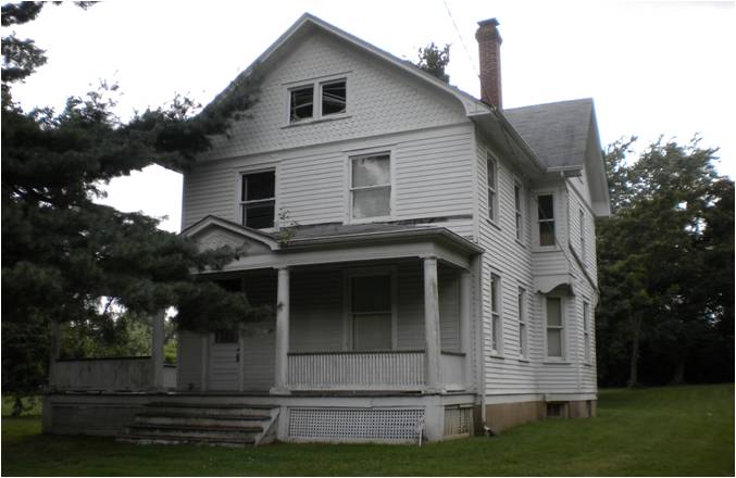
by Dan Allen Rothwell, Historian and Author
from A Guide to Chesterfield's Architectural Treasures
available for purchase at City Hall