P.Z. 03-2024 Chesterfield Village Mall
NOTICE IS HEREBY GIVEN that the Planning Commission of the City of Chesterfield will hold a Public Hearing on Monday, April 8, 2024 at 7:00 pm, in the Council Chambers at the City Hall, 690 Chesterfield Parkway West, Chesterfield, Missouri 63017.
Said Hearing will be as follows:
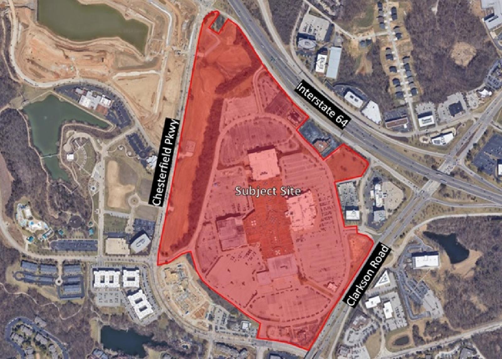
P.Z. 03-2024 Chesterfield Village Mall: An ordinance amendment to add an additional 16.679-acre tract of land zoned “C-8” Planned Commercial to an existing 96.017-acre tract of land zoned “PC&R” Planned Commercial and Residential District located on the south side of Interstate 64, east of Chesterfield Parkway.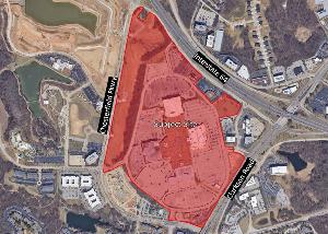
For a larger image of the site, please click HERE.
Anyone interested in the proceedings will be given an opportunity to be heard. Copies of the request are available for review in the Department of Planning at Chesterfield City Hall, 690 Chesterfield Parkway West during weekdays between the hours of 8:30 a.m. and 4:30 p.m. If you should need additional information about this project, please contact Alyssa Ahner, Senior Planner, by telephone at 636-537-4738 or by email at aahner@chesterfield.mo.us.
CITY OF CHESTERFIELD
Guy Tilman, Chair
Chesterfield Planning Commission
PROPERTY DESCRIPTION
Area 1: Beginning at the southeastern corner of Lot C-108 of Chesterfield Village A Phase One Plat One, a subdivision according to the plat thereof as recorded in Plat Book 158, Page 96 of the St. Louis County records, said point also being located on the northern right-of-way line of West Chesterfield Parkway, variable width; thence along the eastern line of said lot C-108, North 02 degrees 24 minutes 55 seconds East, 153.50 feet to the northeastern corner thereof, thence along the northeastern lines of said Lot C108 and Lot 1 of the Chesterfield Village Area “A” Phase One Plat One Lots C109 and C208 Lot Consolidation Plat, a subdivision according to the plat thereof as recorded in Plat Book 367, Page 521 of above said records, the following courses and distances: North 52 degrees 55 minutes 05 seconds West, 837.00 feet; North 18 degrees 15 minutes 05 seconds West, 305.01 feet and North 64 degrees 14 minutes 40 seconds West, 41.67 feet to the beginning of a non-tangent curve to the left having a radius of 432.37 feet; thence along said curve with an arc length of 106.89 feet and a chord which bears South 60 degrees 42 minutes 07 seconds West, 106.62 feet to the beginning of a non-tangent curve to the right having a radius of 338.26 feet an arc length of 254.23 feet and a chord which bears South 73 degrees 46 minutes 00 seconds West, 248.28 feet and North 84 degrees 40 minutes 43 seconds West, 14.47 feet to the eastern right-of-way line of West Chesterfield Parkway, 73 feet wide, said point also being located on a curve to the right having a radius of 763.50 feet; thence along said curve with an arc length of 75.03 feet and a chord which bears North 05 degrees 18 minutes 40 seconds East, 75.00 feet to the southwest corner of Lot C110 of Chesterfield Village Area A Phase 1 Plat 2 according to the plat thereof as recorded in Plat Book 166, Page 84 of above said records, thence along southern and eastern lines of said Chesterfield Village Area A Phase 1 Plat 2 the following courses and distances: South 84 degrees 40 minutes 43 seconds East, 14.48 feet to a non-tangent curve to the left having a radius of 262.50 feet, an arc length of 191.02 feet and a chord which bears North 74 degrees 28 minutes 28 seconds East, 186.83 feet; North 53 degrees 37 minutes 39 seconds East, 8.62 feet to the beginning of a non-tangent curve to the right having a radius of 507.82 feet, an arc length of 160.61 feet and a chord which bears North 62 degrees 41 minutes 17 seconds East, 159.94 feet; North 27 degrees 29 minutes 54 seconds East, 207.73 feet; North 14 degrees 25 minutes 19 seconds East, 758.46 feet and North 08 degrees 46 minutes 20 seconds East, 85.00 feet to the northmost corner of New Section B of the Resubdivision Plat of Lot C101F of Parcel C101F of Chesterfield Village Area A Phase 1 Plat One, Plat Book 334, Pages 65 and 65A; thence along the northern and eastern lines of said New Section B the following courses and distances: South 75 degrees 34 minutes 41 seconds East, 51.88 feet; South 12 degrees 26 minutes 49 seconds East, 123.89 feet and North 77 degrees 33 minutes 11 seconds East, 143.58 feet; thence departing the southern line of said New Section B the following courses and distances: South 12 degrees 23 minutes 25 seconds East, 245.62 feet; North 77 degrees 36 minutes 34 seconds East, 106.66 feet and North 12 degrees 26 minutes 49 seconds West, 5.73 feet to the northern line of above said New Section B; thence along said north line, North 77 degrees 33 minutes 11 seconds East, 451.32 feet and South 12 degrees 26 minutes 49 seconds East, 13.15 feet; thence departing the western line of said New Section B the following: North 77 degrees 33 minutes 11 seconds East, 422.43 feet to the beginning of a non-tangential curve to the right having a radius of 500.16 feet; along said curve with an arc length of 62.49 feet and a chord which beard South 25 degrees 27 minutes 14 seconds East, 62.45 fee to its intersection with the north line of said New Section B; thence along said north line, North 77 degrees 33 minutes 11 seconds East, 61.46 feet and to a point on a non-tangent curve to the left having a radius of 515.00 feet, said point also being located on the west line of Lot C 106 of above said Chesterfield Village A Phase One Plat One; thence along said curve with an arc length of 155.67 feet and a chord which bears North 32 degrees 57 minutes 40 seconds West, 155.08 feet to the western most corner of said Lot C 106; thence along the northwestern lines of said Lot C 106 the following: North 50 degrees 55 minutes 27 seconds East, 245.99 feet and North 32 degrees 52 minutes 18 seconds East, 32.53 feet to its intersection with the southern right-of way line of Chesterfield Airport Road, variable width; thence along said right-of-way line South 57 degrees 07 minutes 42 seconds East, 341.40 feet to the northwest corner of that part of Chesterfield Center vacated by City of Chesterfield Ordinance Number 511, and recorded in Book 8872, Page 2431 of above said records; thence along the north, east and south lines of said vacation the following courses and distances: continuing Southeasterly along said line, South 57 degrees 07 minutes 42 seconds East, 21.18 feet; South 42 degrees 52 minutes 34 seconds East, 8.16 feet to the beginning of a non-tangent curve to the right having a radius of 61.00 feet, an arc length of 31.10 feet and a chord which bears South 13 degrees 33 minutes 13 seconds West, 30.76 feet; South 28 degrees 09 minutes 48 seconds West, 126.11 feet to the beginning of a curve to the right having a radius of 495.58 feet, an arc length of 17.10 feet and a chord which bears South 29 degrees 9 minutes 7 seconds West 17.10 feet; South 30 degrees 07 minutes 59 seconds West, 34.42 feet and North 69 degrees 47 minutes 38 seconds West, 19.46 feet to the eastern most corner of above said Lot C 106; thence along the southern line of said Lot C 106, South 77 degrees 7 minutes 6 seconds West, 290.42 feet; to the east line of New Section A of Lot C101F of above said Resubdivision Plat of Lot C101F of Parcel C101F of Chesterfield Village Area A Phase 1 Plat One; thence along said east lines of said New Section A the following courses and distances: South 12 degrees 26 minutes 49 seconds East, 451.59 feet; South 56 degrees 32 minutes 18 seconds East, 43.09 feet top the beginning of a non- tangent curve to the right having a radius of 473.00 feet, and along said curve with an arc length of 151.21 feet and a chord which bears South 89 degrees 38 minutes 16 seconds East, 150.56 feet; thence crossing Chesterfield Center Drive; South 12 degrees 32 minutes 53 seconds West, 100.14 feet to the north line of Lot C 102 of above said Chesterfield Village A Phase One Plat One, said point also being located on a non-tangent curve to the right having a radius of 373.00 feet; thence along said north line and last said curve with an arc length of 137.75 feet and a chord which bears South 70 degrees 43 minutes 56 seconds East, 136.97 feet; thence South 11 degrees 41 minutes 44 seconds East, 41.56 feet to the western right-of-way line of Clarkson Road, variable width thence along said right-of-way line the following courses and distances: South 34 degrees 27 minutes 25 seconds West, 386.00 feet; South 23 degrees 33 minutes 07 seconds West, 181.60 feet; South 31 degrees 8 minutes 12 seconds West, 828.33 feet and South 85 degrees 41 minutes 13 seconds West, 26.89 feet to the northern right-of-way line of above said West Chesterfield Parkway, said point also being located on a curve to the left having a radius of 1,060.17 feet; thence along said right-of-way line the following courses and distances: along said curve with an arc length of 334.12 feet and a chord which bears North 73 degrees 49 minutes 52 seconds West, 332.74 feet; North 82 degrees 51 minutes 36 seconds West, 126.21 feet; North 82 degrees 52 minutes 12 seconds West, 37.73 feet and South 86 degrees 45 minutes 4 seconds West, 35.95 feet to the POINT OF BEGINNING. Rev 4/17/23
Containing 2,902,238 square feet or 66.626 acres, more or less.
Area 2: A tract of land being Lot C101D of the Chesterfield Village A Phase One Plat One, a subdivision according to the plat thereof as recorded in Plat Book 158, Page 96 of the St. Louis County records, located in U.S. Surveys 415 and 2002, Township 45 North, Range 4 East of the Fifth Principal Meridian, City of Chesterfield, St. Louis County, Missouri being more particularly described as follows:
Beginning at the northernmost corner of above said Lot C101D, said point also being located on the southern right-of-way line of Chesterfield Airport Road, variable width, said point also being located on a curve to the left having a radius of 2,914.93 feet; thence along said right-of-way line the following courses and distances: southeasterly along said curve with an arc length of 477.12 feet and a chord which bears South 40 degrees 27 minutes 57 seconds East, 476.59 feet; South 44 degrees 50 minutes 42 seconds West, 10.00 feet; to the beginning of a curve to the left having a radius of 2,924.93 feet an arc length of 231.79 feet and a chord which bears South 47 degrees 25 minutes 30 seconds East, 231.70 feet to the southeast corner of above said Lot C101D; thence along the southeastern line of said Lot C101D, South 40 degrees 18 minutes 17 seconds West, 194.14 feet to the west line of said Lot C101D; thence along said west line the following courses and distances: North 42 degrees 53 minutes 57 seconds West, a distance of 124.85 feet; South 47 degrees 06 minutes 03 seconds West, 5.00 feet; to the beginning of a non-tangent curve to the left having a radius of 400.00 feet; along said curve with an arc length of 307.06 feet and a chord which bears North 64 degrees 53 minutes 28 seconds West, 299.58 feet to the southwest corner of said Lot C101D; thence along the western lines of said Lot C101D the following: North 12 degrees 26 minutes 49 seconds West, 397.78 feet and North 54 degrees 13 minutes 23 seconds East, 121.24 feet to the POINT OF BEGINNING.
Containing 152,812 square feet or 3.508 acres, more or less.
Area 3: Tracts of land being Lots C110, C111, C112, and C113 of Chesterfield Village Area A Phase One Plat Two as recorded in Plat Book 166, Page 84; and Part of Us. Survey 415, as described in Book 10308, Page 1461 both of the St. Louis County Records, located in U.S. Surveys 415 and 2022, Township 45 North, Range 4 East of the Fifth Principal Meridian, City of Chesterfield, St. Louis County, Missouri being more particularly described as follows:
Beginning at the southwestern corner of above said Lot C110, said point also being located on the eastern right-of-way line of West Chesterfield Parkway, 73 feet wide, Said point also being located on a non-tangent curve to the right having a radius of 763.50 feet, thence along said right-of-way line the following courses and distances: along said curve with an arc length of 45.90 feet and a chord which bears North 10 degrees 04 minutes 33 seconds East, 45.90 feet; North 11 degrees 34 minutes 17 seconds East, 735.22 feet to the beginning of a curve to the left having a radius of 3,036.50 feet; along said curve with an arc length of 79.87 feet and a chord which bears North 10 degrees 49 minutes 04 seconds East 79.87 feet; North 10 degrees 03 minutes 51 seconds East, 1,599.81 feet to the beginning of a non-tangent curve to the right having a radius of 1,113.50 feet and a chord which bears North 17 degrees 03 minutes 36 seconds East, 269.98 feet and North 71 degrees 18 minutes 34 seconds East, 135.85 feet to its intersection with the southern right-of-way line of Chesterfield Airport Road, variable width; thence along said right-of-way line the following: South 69 degrees 05 minutes 13 seconds East, 32.21 feet and South 59 degrees 27 minutes 09 seconds East, 11.64 feet to the northwest corner of a tract of land as conveyed to First Baptist Church, by instrument recorded in Book 5232, Page 199 of above said records, thence along the west, south and eastern lines of said Church tract the following courses and distances: South 34 degrees 10 minutes 41 seconds West, 180.51 feet; South 55 degrees 53 minutes 58 seconds East, 137.63 feet; North 34 degrees 59 minutes 13 seconds East, 43.04 feet; North 15 degrees 05 minutes 30 seconds East, 47.83 feet and North 27 degrees 03 minutes 38 seconds East, 17.67 feet and North 35 degrees 05 minutes 17 seconds East, 82.29 feet to the southern right-of-way line of above said Chesterfield Airport Road; thence along said right-of-way line the following: South 59 degrees 27 minutes 09 seconds East, 84.03 feet and South 33 degrees 54 minutes 11 seconds East, 408.23 feet to the easternmost corner of above said Lot C111; thence along the eastern and southern lines of said Chesterfield Village Area A Phase One Plat Two the following courses and distances: South 02 degrees 31 minutes 25 seconds West, 74.82 feet; South 28 degrees 18 minutes 26 seconds West, 85.00 feet; South 60 degrees 52 minutes 24 seconds West, 334.47 feet; South 08 degrees 46 minutes 20 seconds West, 912.12 feet; South 14 degrees 25 minutes 19 seconds West, a distance of 758.46 feet; South 27 degrees 29 minutes 54 seconds West, 207.73 feet to the beginning of a non-tangent curve to the left having a radius of 507.82 feet; along said curve with an arc length of 160.61 feet and a chord which bears South 62 degrees 41 minutes 17 seconds West, 159.94 feet; South 53 degrees 37 minutes 39 seconds West, a distance of 8.62 feet to the beginning of a non-tangent curve to the right having a radius of 262.50 feet; along said curve with an arc length of 191.02 feet and a chord which bears South 74 degrees 28 minutes 28 seconds West, 186.83 feet and North 84 degrees 40 minutes 43 seconds West, 14.47 feet to the POINT OF BEGINNING.
Containing 1,127,465 square feet or 25.883 acres more or less.
Area 4: A tract of land being Lot C101C of the Chesterfield Village A Phase One Plat One, a subdivision according to the plat thereof as recorded in Plat Book 158, Page 96 of the St. Louis County records, located in U.S. Surveys 415 and 2002, Township 45 North, Range 4 East of the Fifth Principal Meridian, City of Chesterfield, St. Louis County, Missouri being more particularly described as follows:
Beginning at the northernmost corner of above said Lot C101C, said point also being located on the southern right-of-way line of Chesterfield Airport Road, variable width,; thence along said right-of-way line the following courses and distances: South 33 degrees 55 minutes 06 seconds East, 82.93 feet to the beginning of a non-tangent curve to the left having a radius of 2,914.93 feet; along said curve with an arc length of 12.29 and a chord which bears South 34 degrees 02 minutes 13 seconds East, 12.29 feet; South 55 degrees 50 minutes 01 second West, 15.03 feet to the beginning of a curve to the left having a radius of 2,929.93 feet; along said curve with an arc length of 20.37 feet and a chord which bears South 34 degrees 40 minutes 47 seconds East, 20.37 feet; North 55 degrees 44 minutes 16 seconds East, 14.92 feet to the beginning of a non-tangent curve to the left having a radius of 2,914.93 feet; along said curve with an arc length of 62.02 feet and a chord which bears South 35 degrees 10 minutes 01 seconds East, 62.02 feet to the northernmost corner of Lot C101D of above said Chesterfield Village A Phase One Plat One; thence along the western line of said Lot C101D the following courses and distances: South 54 degrees 13 minutes 23 seconds West, 121.24 feet; South 12 degrees 26 minutes 49 seconds East, 397.78 feet to the beginning of a non-tangent curve to the right having a radius of 400.00 feet; along said curve with an arc length of 307.06 feet and a chord which bears South 64 degrees 53 minutes 28 seconds East, 299.58 feet; North 47 degrees 06 minutes 03 seconds East, 5.00 feet; South 42 degrees 53 minutes 57 seconds East, 124.85 feet to the northwest corner of Lot C107 of the Boundary Adjustment Plat of plat of Lots C106 & C107 of Chesterfield Village A Phase One Plat One. as recorded in Plat Book 225, Page 39 of above said records; thence along the west lines of said Lot C107 and C106 , the following: South 42 degrees 50 minutes 52 seconds East, 411.70 feet to the beginning of a non-tangent curve to the right having a radius of 515.00 feet; along said curve with an arc length of 168.39 feet and a chord which bears South 33 degrees 40 minutes 07 seconds East, 167.64 feet to the south line of said Lot C101C,; thence along said south line, South 77 degrees 33 minutes 11 seconds West, 61.46 fee a non-tangent curve to the left having a radius of 500.16 feet; then departing said south line along last said curve with an arc length of 62.49 feet and a chord which bears North 25 degrees 27 minutes 14 seconds West, 62.45 feet; thence South 77 degrees 33 minutes 11 seconds West, 422.43 feet to the east line of said Lot C101C; thence along the east and south lines of said Lot C101C, the following: North 12 degrees 26 minutes 49 seconds West, 13.15 feet and South 77 degrees 33 minutes 11 seconds West, 451.32 feet; thence departing said south line the following courses and distances: South 12 degrees 26 minutes 49 seconds East, 5.73 feet; South 77 degrees 36 minutes 34 seconds West, 106.66 feet and North 12 degrees 23 minutes 25 seconds West, a distance of 245.62 feet to its intersection with the south line of said Lot C101C; thence along the southern and western lines of said Lot C101C the following: South 77 degrees 33 minutes 11 seconds West, 143.58 feet; North 12 degrees 26 minutes 49 seconds West, 123.89 feet and North 75 degrees 34 minutes 41 seconds West, 51.88 feet to the west line of said Lot C101C; thence along said west line, North 08 degrees 46 minutes 20 seconds East, 177.14 feet to the south line of Lot C101E of Chesterfield Village A Phase One Plat One; thence along the northern and eastern lines of said Lot C101E the following courses and distances: North 36 degrees 46 minutes 20 seconds East, 137.91 feet to the beginning of a non-tangent curve to the right having a radius of 400.00 feet; along said curve with an arc length of 284.70 feet and a chord which bears North 57 degrees 09 minutes 42 seconds East, 278.73 feet; North 77 degrees 33 minutes 11 seconds East, 134.34 feet; North 12 degrees 26 minutes 49 seconds West, 419.05 feet and North 28 degrees 18 minutes 26 seconds East, 233.25 feet to the POINT OF BEGINNING.
Containing 726,544 square feet or 16.679 acres, more or less.